You are here: Home > Network List > NE - New England Seismic Network Stations List
> Station EMMW Machias, ME, USA > Earthquake Result Viewer
EMMW Machias, ME, USA - Earthquake Result Viewer
| Earthquake location: |
South Of Panama |
| Earthquake latitude/longitude: |
7.7/-82.3 |
| Earthquake time(UTC): |
2022/10/20 (293) 11:57:14 GMT |
| Earthquake Depth: |
10 km |
| Earthquake Magnitude: |
6.9 Mi |
| Earthquake Catalog/Contributor: |
NEIC PDE/at |
|
| Network: |
NE New England Seismic Network |
| Station: |
EMMW Machias, ME, USA |
| Lat/Lon: |
44.71 N/67.46 W |
| Elevation: |
35 m |
|
| Distance: |
39.1 deg |
| Az: |
16.85 deg |
| Baz: |
203.759 deg |
| Ray Param: |
0.075224556 |
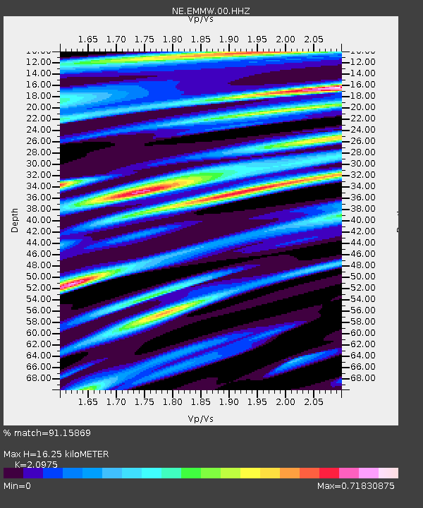
| Estimated Moho Depth: |
16.25 km |
| Estimated Crust Vp/Vs: |
2.10 |
| Assumed Crust Vp: |
6.419 km/s |
| Estimated Crust Vs: |
3.06 km/s |
| Estimated Crust Poisson's Ratio: |
0.35 |
|
| Radial Match: |
91.15869 % |
| Radial Bump: |
340 |
| Transverse Match: |
61.269753 % |
| Transverse Bump: |
400 |
| SOD ConfigId: |
28764291 |
| Insert Time: |
2022-11-03 12:24:21.345 +0000 |
| GWidth: |
2.5 |
| Max Bumps: |
400 |
| Tol: |
0.001 |
|
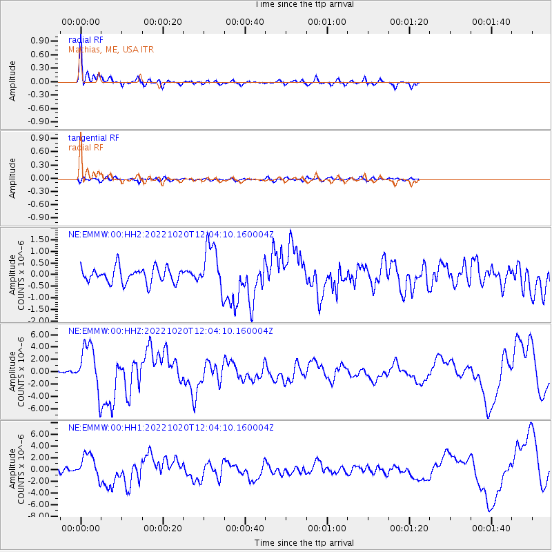
Signal To Noise
| Channel | StoN | STA | LTA |
| NE:EMMW:00:HHZ:20221020T12:04:10.160004Z | 8.331618 | 3.8203543E-6 | 4.585369E-7 |
| NE:EMMW:00:HH1:20221020T12:04:10.160004Z | 4.576023 | 2.1028068E-6 | 4.5952714E-7 |
| NE:EMMW:00:HH2:20221020T12:04:10.160004Z | 3.1280224 | 1.0211102E-6 | 3.264395E-7 |
| Arrivals |
| Ps | 3.0 SECOND |
| PpPs | 7.4 SECOND |
| PsPs/PpSs | 10 SECOND |


