You are here: Home > Network List > NM - Cooperative New Madrid Seismic Network Stations List
> Station MGMO Mountain Grove, MO > Earthquake Result Viewer
MGMO Mountain Grove, MO - Earthquake Result Viewer
| Earthquake location: |
South Of Panama |
| Earthquake latitude/longitude: |
7.7/-82.3 |
| Earthquake time(UTC): |
2022/10/20 (293) 11:57:14 GMT |
| Earthquake Depth: |
10 km |
| Earthquake Magnitude: |
6.9 Mi |
| Earthquake Catalog/Contributor: |
NEIC PDE/at |
|
| Network: |
NM Cooperative New Madrid Seismic Network |
| Station: |
MGMO Mountain Grove, MO |
| Lat/Lon: |
37.15 N/92.27 W |
| Elevation: |
453 m |
|
| Distance: |
30.7 deg |
| Az: |
344.277 deg |
| Baz: |
160.357 deg |
| Ray Param: |
0.07934274 |
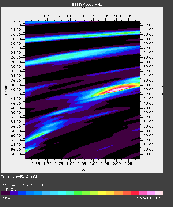
| Estimated Moho Depth: |
39.75 km |
| Estimated Crust Vp/Vs: |
2.00 |
| Assumed Crust Vp: |
6.53 km/s |
| Estimated Crust Vs: |
3.265 km/s |
| Estimated Crust Poisson's Ratio: |
0.33 |
|
| Radial Match: |
92.27832 % |
| Radial Bump: |
175 |
| Transverse Match: |
77.33688 % |
| Transverse Bump: |
397 |
| SOD ConfigId: |
28764291 |
| Insert Time: |
2022-11-03 12:24:34.668 +0000 |
| GWidth: |
2.5 |
| Max Bumps: |
400 |
| Tol: |
0.001 |
|

Signal To Noise
| Channel | StoN | STA | LTA |
| NM:MGMO:00:HHZ:20221020T12:02:58.130005Z | 21.80139 | 2.9230118E-6 | 1.3407457E-7 |
| NM:MGMO:00:HHN:20221020T12:02:58.130005Z | 11.059822 | 1.7902161E-6 | 1.6186662E-7 |
| NM:MGMO:00:HHE:20221020T12:02:58.130005Z | 3.8499315 | 4.038976E-7 | 1.04910335E-7 |
| Arrivals |
| Ps | 6.6 SECOND |
| PpPs | 17 SECOND |
| PsPs/PpSs | 24 SECOND |


