You are here: Home > Network List > O2 - Oklahoma Consolidated Temporary Seismic Networks Stations List
> Station GORE Near Medford, Oklahoma, USA > Earthquake Result Viewer
GORE Near Medford, Oklahoma, USA - Earthquake Result Viewer
| Earthquake location: |
South Of Panama |
| Earthquake latitude/longitude: |
7.7/-82.3 |
| Earthquake time(UTC): |
2022/10/20 (293) 11:57:14 GMT |
| Earthquake Depth: |
10 km |
| Earthquake Magnitude: |
6.9 Mi |
| Earthquake Catalog/Contributor: |
NEIC PDE/at |
|
| Network: |
O2 Oklahoma Consolidated Temporary Seismic Networks |
| Station: |
GORE Near Medford, Oklahoma, USA |
| Lat/Lon: |
36.79 N/97.95 W |
| Elevation: |
348 m |
|
| Distance: |
32.3 deg |
| Az: |
336.075 deg |
| Baz: |
149.956 deg |
| Ray Param: |
0.07873906 |
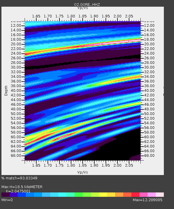
| Estimated Moho Depth: |
18.5 km |
| Estimated Crust Vp/Vs: |
2.05 |
| Assumed Crust Vp: |
6.483 km/s |
| Estimated Crust Vs: |
3.166 km/s |
| Estimated Crust Poisson's Ratio: |
0.34 |
|
| Radial Match: |
93.83349 % |
| Radial Bump: |
372 |
| Transverse Match: |
79.149956 % |
| Transverse Bump: |
359 |
| SOD ConfigId: |
28764291 |
| Insert Time: |
2022-11-03 12:26:30.353 +0000 |
| GWidth: |
2.5 |
| Max Bumps: |
400 |
| Tol: |
0.001 |
|

Signal To Noise
| Channel | StoN | STA | LTA |
| O2:GORE: :HHZ:20221020T12:03:12.000Z | 8.429773 | 1.1236419E-7 | 1.3329443E-8 |
| O2:GORE: :HHN:20221020T12:03:12.000Z | 3.1491294 | 6.0188285E-7 | 1.9112673E-7 |
| O2:GORE: :HHE:20221020T12:03:12.000Z | 2.8694239 | 3.2838622E-7 | 1.1444326E-7 |
| Arrivals |
| Ps | 3.2 SECOND |
| PpPs | 8.1 SECOND |
| PsPs/PpSs | 11 SECOND |


