You are here: Home > Network List > O2 - Oklahoma Consolidated Temporary Seismic Networks Stations List
> Station SC17 Lindsey, Oklahoma, USA > Earthquake Result Viewer
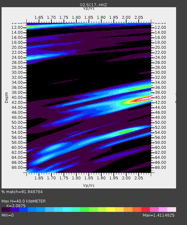
SC17 Lindsey, Oklahoma, USA - Earthquake Result Viewer
| Earthquake location: |
South Of Panama |
| Earthquake latitude/longitude: |
7.7/-82.3 |
| Earthquake time(UTC): |
2022/10/20 (293) 11:57:14 GMT |
| Earthquake Depth: |
10 km |
| Earthquake Magnitude: |
6.9 Mi |
| Earthquake Catalog/Contributor: |
NEIC PDE/at |
|
| Network: |
O2 Oklahoma Consolidated Temporary Seismic Networks |
| Station: |
SC17 Lindsey, Oklahoma, USA |
| Lat/Lon: |
34.92 N/97.60 W |
| Elevation: |
1126 m |
|
| Distance: |
30.5 deg |
| Az: |
334.725 deg |
| Baz: |
149.007 deg |
| Ray Param: |
0.07939676 |
| Estimated Moho Depth: |
40.0 km |
| Estimated Crust Vp/Vs: |
2.09 |
| Assumed Crust Vp: |
6.426 km/s |
| Estimated Crust Vs: |
3.078 km/s |
| Estimated Crust Poisson's Ratio: |
0.35 |
|
| Radial Match: |
91.948784 % |
| Radial Bump: |
255 |
| Transverse Match: |
57.99492 % |
| Transverse Bump: |
400 |
| SOD ConfigId: |
28764291 |
| Insert Time: |
2022-11-03 12:27:18.325 +0000 |
| GWidth: |
2.5 |
| Max Bumps: |
400 |
| Tol: |
0.001 |
|

Signal To Noise
| Channel | StoN | STA | LTA |
| O2:SC17: :HHZ:20221020T12:02:56.625Z | 9.093082 | 2.0536258E-6 | 2.2584486E-7 |
| O2:SC17: :HHN:20221020T12:02:56.625Z | 5.24955 | 1.4877432E-6 | 2.8340395E-7 |
| O2:SC17: :HHE:20221020T12:02:56.625Z | 3.478846 | 9.53218E-7 | 2.7400407E-7 |
| Arrivals |
| Ps | 7.2 SECOND |
| PpPs | 18 SECOND |
| PsPs/PpSs | 25 SECOND |


