You are here: Home > Network List > O2 - Oklahoma Consolidated Temporary Seismic Networks Stations List
> Station SC20 Lookeba, Oklahoma, USA > Earthquake Result Viewer
SC20 Lookeba, Oklahoma, USA - Earthquake Result Viewer
| Earthquake location: |
South Of Panama |
| Earthquake latitude/longitude: |
7.7/-82.3 |
| Earthquake time(UTC): |
2022/10/20 (293) 11:57:14 GMT |
| Earthquake Depth: |
10 km |
| Earthquake Magnitude: |
6.9 Mi |
| Earthquake Catalog/Contributor: |
NEIC PDE/at |
|
| Network: |
O2 Oklahoma Consolidated Temporary Seismic Networks |
| Station: |
SC20 Lookeba, Oklahoma, USA |
| Lat/Lon: |
35.40 N/98.44 W |
| Elevation: |
490 m |
|
| Distance: |
31.3 deg |
| Az: |
334.073 deg |
| Baz: |
147.965 deg |
| Ray Param: |
0.07912995 |
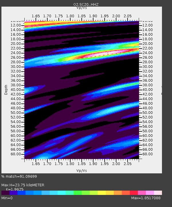
| Estimated Moho Depth: |
23.75 km |
| Estimated Crust Vp/Vs: |
1.96 |
| Assumed Crust Vp: |
6.315 km/s |
| Estimated Crust Vs: |
3.218 km/s |
| Estimated Crust Poisson's Ratio: |
0.32 |
|
| Radial Match: |
91.09699 % |
| Radial Bump: |
400 |
| Transverse Match: |
69.2214 % |
| Transverse Bump: |
400 |
| SOD ConfigId: |
28764291 |
| Insert Time: |
2022-11-03 12:27:24.106 +0000 |
| GWidth: |
2.5 |
| Max Bumps: |
400 |
| Tol: |
0.001 |
|

Signal To Noise
| Channel | StoN | STA | LTA |
| O2:SC20: :HHZ:20221020T12:03:03.450012Z | 11.454545 | 2.556444E-6 | 2.2318163E-7 |
| O2:SC20: :HHN:20221020T12:03:03.450012Z | 4.787506 | 1.4360289E-6 | 2.9995343E-7 |
| O2:SC20: :HHE:20221020T12:03:03.450012Z | 2.113931 | 6.990976E-7 | 3.3070975E-7 |
| Arrivals |
| Ps | 3.9 SECOND |
| PpPs | 10 SECOND |
| PsPs/PpSs | 14 SECOND |


