You are here: Home > Network List > XA95 - Missouri to Massachusetts Transect Stations List
> Station MM07 Sigel, Pennsylvania > Earthquake Result Viewer
MM07 Sigel, Pennsylvania - Earthquake Result Viewer
| Earthquake location: |
Near Coast Of Peru |
| Earthquake latitude/longitude: |
-10.5/-78.7 |
| Earthquake time(UTC): |
1995/09/23 (266) 22:31:58 GMT |
| Earthquake Depth: |
73 km |
| Earthquake Magnitude: |
5.9 MB, 6.5 UNKNOWN, 6.4 MW |
| Earthquake Catalog/Contributor: |
WHDF/NEIC |
|
| Network: |
XA Missouri to Massachusetts Transect |
| Station: |
MM07 Sigel, Pennsylvania |
| Lat/Lon: |
41.26 N/79.14 W |
| Elevation: |
518 m |
|
| Distance: |
51.5 deg |
| Az: |
359.578 deg |
| Baz: |
179.45 deg |
| Ray Param: |
0.067138545 |
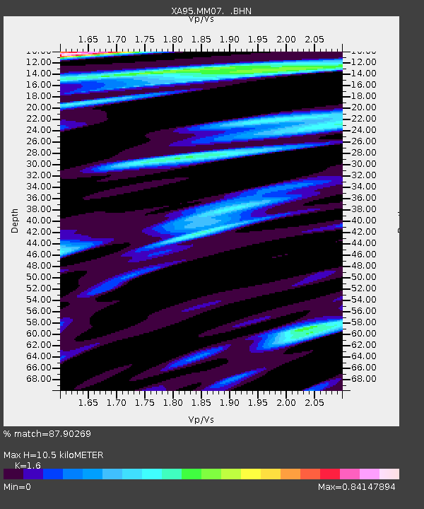
| Estimated Moho Depth: |
10.5 km |
| Estimated Crust Vp/Vs: |
1.60 |
| Assumed Crust Vp: |
6.121 km/s |
| Estimated Crust Vs: |
3.825 km/s |
| Estimated Crust Poisson's Ratio: |
0.18 |
|
| Radial Match: |
87.90269 % |
| Radial Bump: |
376 |
| Transverse Match: |
67.11532 % |
| Transverse Bump: |
400 |
| SOD ConfigId: |
6273 |
| Insert Time: |
2010-02-26 17:48:03.161 +0000 |
| GWidth: |
2.5 |
| Max Bumps: |
400 |
| Tol: |
0.001 |
|
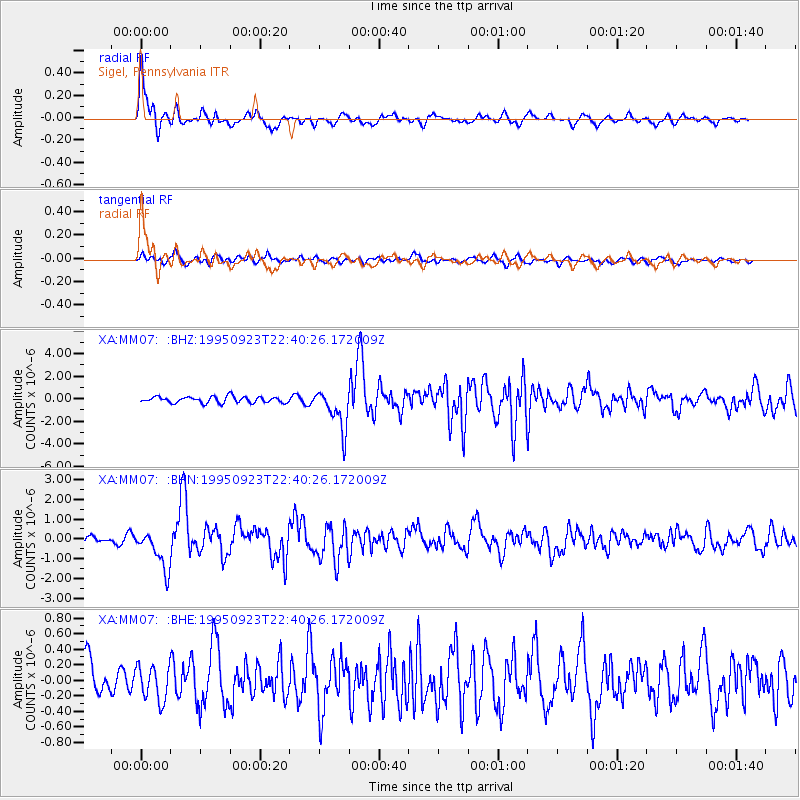
Signal To Noise
| Channel | StoN | STA | LTA |
| XA:MM07: :BHN:19950923T22:40:26.172009Z | 4.676434 | 9.933561E-7 | 2.1241746E-7 |
| XA:MM07: :BHE:19950923T22:40:26.172009Z | 1.0218849 | 2.2034266E-7 | 2.1562374E-7 |
| XA:MM07: :BHZ:19950923T22:40:26.172009Z | 6.6195297 | 1.7963062E-6 | 2.7136463E-7 |
| Arrivals |
| Ps | 1.1 SECOND |
| PpPs | 4.2 SECOND |
| PsPs/PpSs | 5.3 SECOND |


