You are here: Home > Network List > TX - Texas Seismological Network Stations List
> Station MB09 Lenorah > Earthquake Result Viewer
MB09 Lenorah - Earthquake Result Viewer
| Earthquake location: |
South Of Panama |
| Earthquake latitude/longitude: |
7.7/-82.3 |
| Earthquake time(UTC): |
2022/10/20 (293) 11:57:14 GMT |
| Earthquake Depth: |
10 km |
| Earthquake Magnitude: |
6.9 Mi |
| Earthquake Catalog/Contributor: |
NEIC PDE/at |
|
| Network: |
TX Texas Seismological Network |
| Station: |
MB09 Lenorah |
| Lat/Lon: |
32.34 N/101.82 W |
| Elevation: |
798 m |
|
| Distance: |
30.5 deg |
| Az: |
326.132 deg |
| Baz: |
139.272 deg |
| Ray Param: |
0.079402395 |
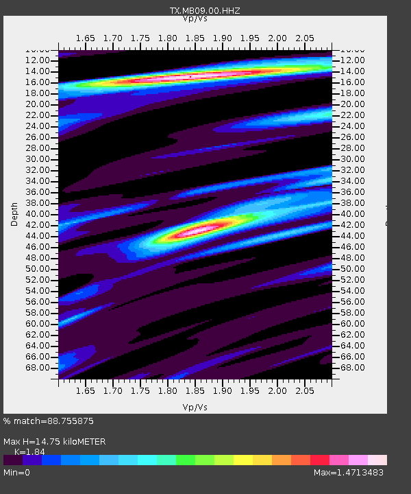
| Estimated Moho Depth: |
14.75 km |
| Estimated Crust Vp/Vs: |
1.84 |
| Assumed Crust Vp: |
6.426 km/s |
| Estimated Crust Vs: |
3.492 km/s |
| Estimated Crust Poisson's Ratio: |
0.29 |
|
| Radial Match: |
88.755875 % |
| Radial Bump: |
355 |
| Transverse Match: |
59.695538 % |
| Transverse Bump: |
400 |
| SOD ConfigId: |
28764291 |
| Insert Time: |
2022-11-03 12:32:30.340 +0000 |
| GWidth: |
2.5 |
| Max Bumps: |
400 |
| Tol: |
0.001 |
|

Signal To Noise
| Channel | StoN | STA | LTA |
| TX:MB09:00:HHZ:20221020T12:02:56.470001Z | 14.824673 | 2.4404203E-6 | 1.6461884E-7 |
| TX:MB09:00:HHN:20221020T12:02:56.470001Z | 4.947983 | 1.0955024E-6 | 2.2140385E-7 |
| TX:MB09:00:HHE:20221020T12:02:56.470001Z | 6.723745 | 1.2953575E-6 | 1.9265417E-7 |
| Arrivals |
| Ps | 2.1 SECOND |
| PpPs | 6.0 SECOND |
| PsPs/PpSs | 8.1 SECOND |


