You are here: Home > Network List > US - United States National Seismic Network Stations List
> Station AMTX Amarillo, Texas, USA > Earthquake Result Viewer
AMTX Amarillo, Texas, USA - Earthquake Result Viewer
*The percent match for this event was below the threshold and hence no stack was calculated.
| Earthquake location: |
South Of Panama |
| Earthquake latitude/longitude: |
7.7/-82.3 |
| Earthquake time(UTC): |
2022/10/20 (293) 11:57:14 GMT |
| Earthquake Depth: |
10 km |
| Earthquake Magnitude: |
6.9 Mi |
| Earthquake Catalog/Contributor: |
NEIC PDE/at |
|
| Network: |
US United States National Seismic Network |
| Station: |
AMTX Amarillo, Texas, USA |
| Lat/Lon: |
34.53 N/101.41 W |
| Elevation: |
1010 m |
|
| Distance: |
32.0 deg |
| Az: |
329.312 deg |
| Baz: |
142.217 deg |
| Ray Param: |
$rayparam |
*The percent match for this event was below the threshold and hence was not used in the summary stack. |
|
| Radial Match: |
90.5207 % |
| Radial Bump: |
233 |
| Transverse Match: |
51.715904 % |
| Transverse Bump: |
400 |
| SOD ConfigId: |
28764291 |
| Insert Time: |
2022-11-03 12:34:06.519 +0000 |
| GWidth: |
2.5 |
| Max Bumps: |
400 |
| Tol: |
0.001 |
|
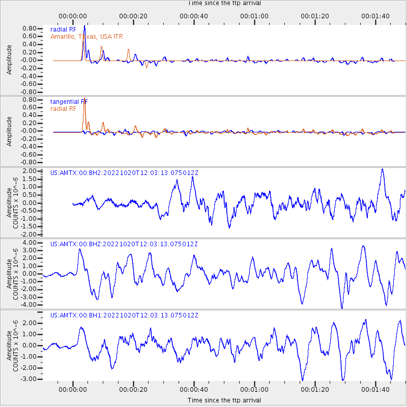
Signal To Noise
| Channel | StoN | STA | LTA |
| US:AMTX:00:BHZ:20221020T12:03:13.075012Z | 10.284182 | 1.5443287E-6 | 1.5016546E-7 |
| US:AMTX:00:BH1:20221020T12:03:13.075012Z | 5.596203 | 8.938929E-7 | 1.5973204E-7 |
| US:AMTX:00:BH2:20221020T12:03:13.075012Z | 3.2131581 | 5.7622805E-7 | 1.7933385E-7 |
| Arrivals |
| Ps | |
| PpPs | |
| PsPs/PpSs | |


