You are here: Home > Network List > US - United States National Seismic Network Stations List
> Station MSO Missoula, Montana, USA > Earthquake Result Viewer
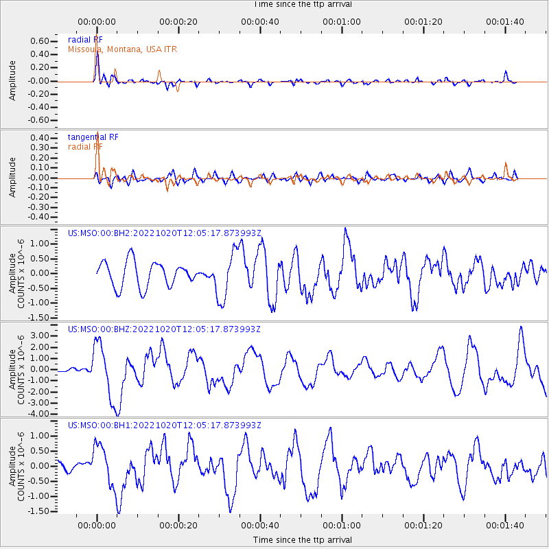
MSO Missoula, Montana, USA - Earthquake Result Viewer
*The percent match for this event was below the threshold and hence no stack was calculated.
| Earthquake location: |
South Of Panama |
| Earthquake latitude/longitude: |
7.7/-82.3 |
| Earthquake time(UTC): |
2022/10/20 (293) 11:57:14 GMT |
| Earthquake Depth: |
10 km |
| Earthquake Magnitude: |
6.9 Mi |
| Earthquake Catalog/Contributor: |
NEIC PDE/at |
|
| Network: |
US United States National Seismic Network |
| Station: |
MSO Missoula, Montana, USA |
| Lat/Lon: |
46.83 N/113.94 W |
| Elevation: |
1264 m |
|
| Distance: |
47.5 deg |
| Az: |
330.734 deg |
| Baz: |
135.117 deg |
| Ray Param: |
$rayparam |
*The percent match for this event was below the threshold and hence was not used in the summary stack. |
|
| Radial Match: |
70.11577 % |
| Radial Bump: |
387 |
| Transverse Match: |
47.64657 % |
| Transverse Bump: |
400 |
| SOD ConfigId: |
28764291 |
| Insert Time: |
2022-11-03 12:34:44.754 +0000 |
| GWidth: |
2.5 |
| Max Bumps: |
400 |
| Tol: |
0.001 |
|
Signal To Noise
| Channel | StoN | STA | LTA |
| US:MSO:00:BHZ:20221020T12:05:17.873993Z | 8.575064 | 2.540887E-6 | 2.9631119E-7 |
| US:MSO:00:BH1:20221020T12:05:17.873993Z | 2.6112247 | 6.883363E-7 | 2.636067E-7 |
| US:MSO:00:BH2:20221020T12:05:17.873993Z | 1.9925935 | 8.3658887E-7 | 4.1984924E-7 |
| Arrivals |
| Ps | |
| PpPs | |
| PsPs/PpSs | |


