You are here: Home > Network List > US - United States National Seismic Network Stations List
> Station OGNE Ogallala, Nebraska, USA > Earthquake Result Viewer
OGNE Ogallala, Nebraska, USA - Earthquake Result Viewer
| Earthquake location: |
South Of Panama |
| Earthquake latitude/longitude: |
7.7/-82.3 |
| Earthquake time(UTC): |
2022/10/20 (293) 11:57:14 GMT |
| Earthquake Depth: |
10 km |
| Earthquake Magnitude: |
6.9 Mi |
| Earthquake Catalog/Contributor: |
NEIC PDE/at |
|
| Network: |
US United States National Seismic Network |
| Station: |
OGNE Ogallala, Nebraska, USA |
| Lat/Lon: |
40.95 N/102.03 W |
| Elevation: |
1054 m |
|
| Distance: |
37.5 deg |
| Az: |
335.144 deg |
| Baz: |
146.636 deg |
| Ray Param: |
0.07611959 |
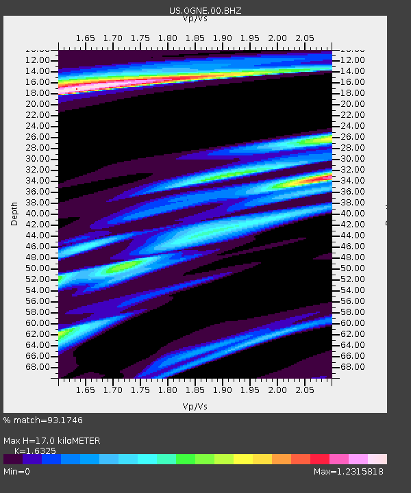
| Estimated Moho Depth: |
17.0 km |
| Estimated Crust Vp/Vs: |
1.63 |
| Assumed Crust Vp: |
6.483 km/s |
| Estimated Crust Vs: |
3.971 km/s |
| Estimated Crust Poisson's Ratio: |
0.20 |
|
| Radial Match: |
93.1746 % |
| Radial Bump: |
235 |
| Transverse Match: |
66.93233 % |
| Transverse Bump: |
369 |
| SOD ConfigId: |
28764291 |
| Insert Time: |
2022-11-03 12:34:50.421 +0000 |
| GWidth: |
2.5 |
| Max Bumps: |
400 |
| Tol: |
0.001 |
|

Signal To Noise
| Channel | StoN | STA | LTA |
| US:OGNE:00:BHZ:20221020T12:03:56.850006Z | 26.638819 | 4.31861E-6 | 1.6211717E-7 |
| US:OGNE:00:BH1:20221020T12:03:56.850006Z | 5.997306 | 2.152129E-6 | 3.5884926E-7 |
| US:OGNE:00:BH2:20221020T12:03:56.850006Z | 4.6326575 | 2.2909358E-6 | 4.945187E-7 |
| Arrivals |
| Ps | 1.8 SECOND |
| PpPs | 6.4 SECOND |
| PsPs/PpSs | 8.2 SECOND |


