You are here: Home > Network List > US - United States National Seismic Network Stations List
> Station WUAZ Wupatki, Arizona, USA > Earthquake Result Viewer
WUAZ Wupatki, Arizona, USA - Earthquake Result Viewer

| Earthquake location: |
South Of Panama |
| Earthquake latitude/longitude: |
7.7/-82.3 |
| Earthquake time(UTC): |
2022/10/20 (293) 11:57:14 GMT |
| Earthquake Depth: |
10 km |
| Earthquake Magnitude: |
6.9 Mi |
| Earthquake Catalog/Contributor: |
NEIC PDE/at |
|
| Network: |
US United States National Seismic Network |
| Station: |
WUAZ Wupatki, Arizona, USA |
| Lat/Lon: |
35.52 N/111.37 W |
| Elevation: |
1592 m |
|
| Distance: |
38.4 deg |
| Az: |
320.348 deg |
| Baz: |
129.172 deg |
| Ray Param: |
0.07560663 |
| Estimated Moho Depth: |
41.0 km |
| Estimated Crust Vp/Vs: |
1.95 |
| Assumed Crust Vp: |
6.207 km/s |
| Estimated Crust Vs: |
3.179 km/s |
| Estimated Crust Poisson's Ratio: |
0.32 |
|
| Radial Match: |
95.45506 % |
| Radial Bump: |
400 |
| Transverse Match: |
82.90872 % |
| Transverse Bump: |
400 |
| SOD ConfigId: |
28764291 |
| Insert Time: |
2022-11-03 12:35:01.197 +0000 |
| GWidth: |
2.5 |
| Max Bumps: |
400 |
| Tol: |
0.001 |
|
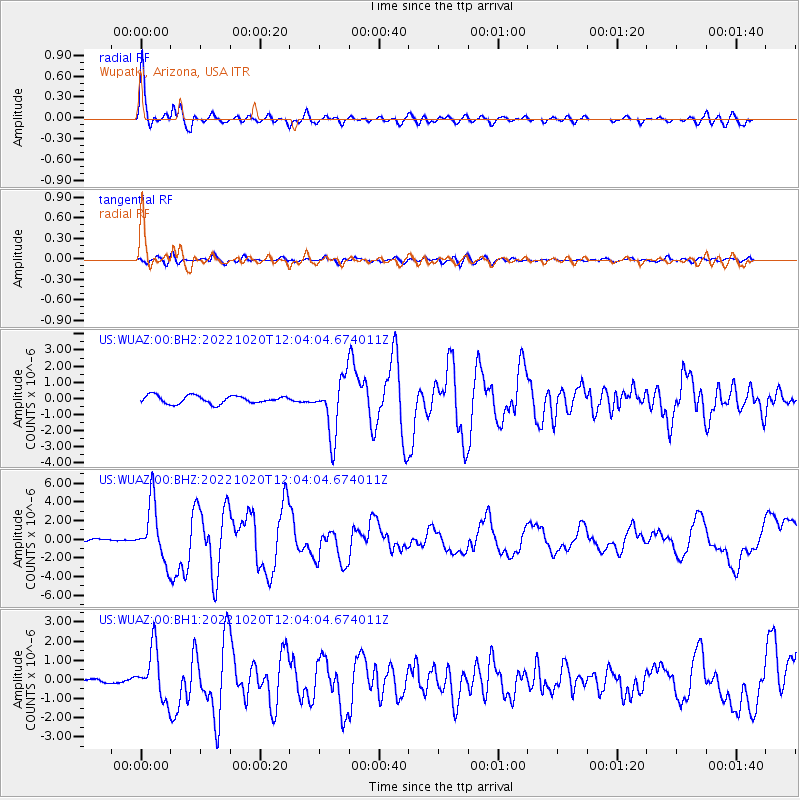
Signal To Noise
| Channel | StoN | STA | LTA |
| US:WUAZ:00:BHZ:20221020T12:04:04.674011Z | 16.74399 | 3.024521E-6 | 1.8063322E-7 |
| US:WUAZ:00:BH1:20221020T12:04:04.674011Z | 7.955338 | 1.318572E-6 | 1.6574683E-7 |
| US:WUAZ:00:BH2:20221020T12:04:04.674011Z | 7.2559376 | 1.760825E-6 | 2.4267365E-7 |
| Arrivals |
| Ps | 6.7 SECOND |
| PpPs | 18 SECOND |
| PsPs/PpSs | 25 SECOND |


