You are here: Home > Network List > UU - University of Utah Regional Network Stations List
> Station TMU Trail Mountain (BB), UT, USA > Earthquake Result Viewer
TMU Trail Mountain (BB), UT, USA - Earthquake Result Viewer
| Earthquake location: |
South Of Panama |
| Earthquake latitude/longitude: |
7.7/-82.3 |
| Earthquake time(UTC): |
2022/10/20 (293) 11:57:14 GMT |
| Earthquake Depth: |
10 km |
| Earthquake Magnitude: |
6.9 Mi |
| Earthquake Catalog/Contributor: |
NEIC PDE/at |
|
| Network: |
UU University of Utah Regional Network |
| Station: |
TMU Trail Mountain (BB), UT, USA |
| Lat/Lon: |
39.30 N/111.21 W |
| Elevation: |
2731 m |
|
| Distance: |
40.8 deg |
| Az: |
324.952 deg |
| Baz: |
132.821 deg |
| Ray Param: |
0.07419821 |
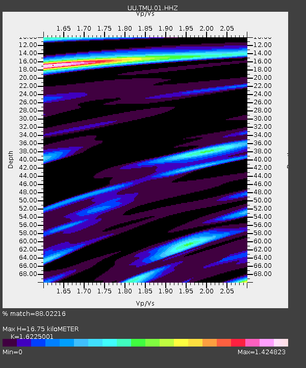
| Estimated Moho Depth: |
16.75 km |
| Estimated Crust Vp/Vs: |
1.62 |
| Assumed Crust Vp: |
6.207 km/s |
| Estimated Crust Vs: |
3.825 km/s |
| Estimated Crust Poisson's Ratio: |
0.19 |
|
| Radial Match: |
88.02216 % |
| Radial Bump: |
374 |
| Transverse Match: |
74.49583 % |
| Transverse Bump: |
400 |
| SOD ConfigId: |
28764291 |
| Insert Time: |
2022-11-03 12:35:28.310 +0000 |
| GWidth: |
2.5 |
| Max Bumps: |
400 |
| Tol: |
0.001 |
|

Signal To Noise
| Channel | StoN | STA | LTA |
| UU:TMU:01:HHZ:20221020T12:04:24.429993Z | 14.5822935 | 3.0631545E-6 | 2.1005985E-7 |
| UU:TMU:01:HHN:20221020T12:04:24.429993Z | 4.2856035 | 1.1825717E-6 | 2.7594055E-7 |
| UU:TMU:01:HHE:20221020T12:04:24.429993Z | 3.0263393 | 1.1216446E-6 | 3.706275E-7 |
| Arrivals |
| Ps | 1.8 SECOND |
| PpPs | 6.6 SECOND |
| PsPs/PpSs | 8.4 SECOND |


