You are here: Home > Network List > UW - Pacific Northwest Regional Seismic Network Stations List
> Station WAT2 Waterville, WA, USA > Earthquake Result Viewer
WAT2 Waterville, WA, USA - Earthquake Result Viewer
| Earthquake location: |
South Of Panama |
| Earthquake latitude/longitude: |
7.7/-82.3 |
| Earthquake time(UTC): |
2022/10/20 (293) 11:57:14 GMT |
| Earthquake Depth: |
10 km |
| Earthquake Magnitude: |
6.9 Mi |
| Earthquake Catalog/Contributor: |
NEIC PDE/at |
|
| Network: |
UW Pacific Northwest Regional Seismic Network |
| Station: |
WAT2 Waterville, WA, USA |
| Lat/Lon: |
47.62 N/120.11 W |
| Elevation: |
875 m |
|
| Distance: |
51.1 deg |
| Az: |
327.804 deg |
| Baz: |
128.685 deg |
| Ray Param: |
0.067623705 |
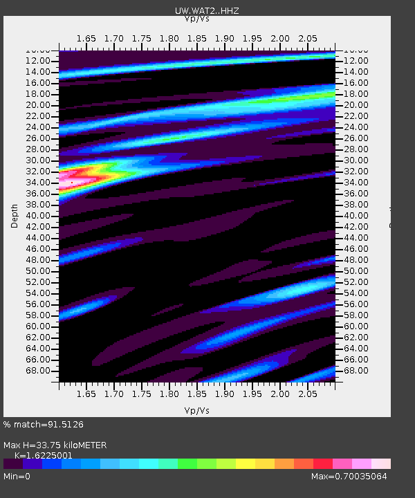
| Estimated Moho Depth: |
33.75 km |
| Estimated Crust Vp/Vs: |
1.62 |
| Assumed Crust Vp: |
6.597 km/s |
| Estimated Crust Vs: |
4.066 km/s |
| Estimated Crust Poisson's Ratio: |
0.19 |
|
| Radial Match: |
91.5126 % |
| Radial Bump: |
322 |
| Transverse Match: |
74.89641 % |
| Transverse Bump: |
400 |
| SOD ConfigId: |
28764291 |
| Insert Time: |
2022-11-03 12:37:53.246 +0000 |
| GWidth: |
2.5 |
| Max Bumps: |
400 |
| Tol: |
0.001 |
|

Signal To Noise
| Channel | StoN | STA | LTA |
| UW:WAT2: :HHZ:20221020T12:05:45.809998Z | 8.497829 | 3.7711395E-6 | 4.437768E-7 |
| UW:WAT2: :HHN:20221020T12:05:45.809998Z | 2.724692 | 8.489319E-7 | 3.1156986E-7 |
| UW:WAT2: :HHE:20221020T12:05:45.809998Z | 3.6870427 | 1.4896098E-6 | 4.0401207E-7 |
| Arrivals |
| Ps | 3.4 SECOND |
| PpPs | 13 SECOND |
| PsPs/PpSs | 16 SECOND |


