You are here: Home > Network List > US - United States National Seismic Network Stations List
> Station RLMT Red Lodge, Montana, USA > Earthquake Result Viewer
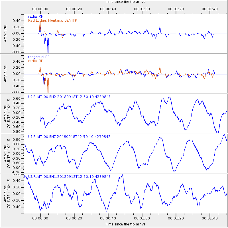
RLMT Red Lodge, Montana, USA - Earthquake Result Viewer
*The percent match for this event was below the threshold and hence no stack was calculated.
| Earthquake location: |
Fiji Islands Region |
| Earthquake latitude/longitude: |
-20.5/-178.2 |
| Earthquake time(UTC): |
2018/09/18 (261) 12:38:35 GMT |
| Earthquake Depth: |
516 km |
| Earthquake Magnitude: |
5.5 Mww |
| Earthquake Catalog/Contributor: |
NEIC PDE/us |
|
| Network: |
US United States National Seismic Network |
| Station: |
RLMT Red Lodge, Montana, USA |
| Lat/Lon: |
45.12 N/109.27 W |
| Elevation: |
2086 m |
|
| Distance: |
90.4 deg |
| Az: |
41.359 deg |
| Baz: |
241.023 deg |
| Ray Param: |
$rayparam |
*The percent match for this event was below the threshold and hence was not used in the summary stack. |
|
| Radial Match: |
88.15927 % |
| Radial Bump: |
400 |
| Transverse Match: |
75.26517 % |
| Transverse Bump: |
400 |
| SOD ConfigId: |
2825771 |
| Insert Time: |
2018-10-02 12:43:06.236 +0000 |
| GWidth: |
2.5 |
| Max Bumps: |
400 |
| Tol: |
0.001 |
|
Signal To Noise
| Channel | StoN | STA | LTA |
| US:RLMT:00:BHZ:20180918T12:50:10.423984Z | 1.440405 | 4.6281403E-7 | 3.2130825E-7 |
| US:RLMT:00:BH1:20180918T12:50:10.423984Z | 1.7006407 | 4.893416E-7 | 2.8773954E-7 |
| US:RLMT:00:BH2:20180918T12:50:10.423984Z | 1.5976362 | 4.4263334E-7 | 2.7705514E-7 |
| Arrivals |
| Ps | |
| PpPs | |
| PsPs/PpSs | |


