You are here: Home > Network List > UW - Pacific Northwest Regional Seismic Network Stations List
> Station LCV Les Collines Vineyard, Walla Walla, WA, USA > Earthquake Result Viewer
LCV Les Collines Vineyard, Walla Walla, WA, USA - Earthquake Result Viewer
| Earthquake location: |
South Of Panama |
| Earthquake latitude/longitude: |
7.7/-82.3 |
| Earthquake time(UTC): |
2022/10/20 (293) 11:57:14 GMT |
| Earthquake Depth: |
10 km |
| Earthquake Magnitude: |
6.9 Mi |
| Earthquake Catalog/Contributor: |
NEIC PDE/at |
|
| Network: |
UW Pacific Northwest Regional Seismic Network |
| Station: |
LCV Les Collines Vineyard, Walla Walla, WA, USA |
| Lat/Lon: |
46.01 N/118.28 W |
| Elevation: |
361 m |
|
| Distance: |
49.1 deg |
| Az: |
327.213 deg |
| Baz: |
129.642 deg |
| Ray Param: |
0.06890748 |
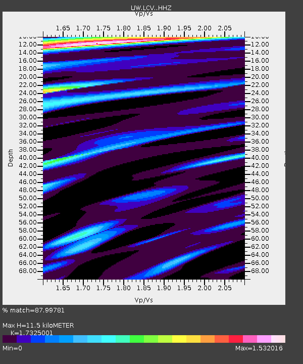
| Estimated Moho Depth: |
11.5 km |
| Estimated Crust Vp/Vs: |
1.73 |
| Assumed Crust Vp: |
6.419 km/s |
| Estimated Crust Vs: |
3.705 km/s |
| Estimated Crust Poisson's Ratio: |
0.25 |
|
| Radial Match: |
87.99781 % |
| Radial Bump: |
372 |
| Transverse Match: |
57.14269 % |
| Transverse Bump: |
400 |
| SOD ConfigId: |
28764291 |
| Insert Time: |
2022-11-03 12:38:04.390 +0000 |
| GWidth: |
2.5 |
| Max Bumps: |
400 |
| Tol: |
0.001 |
|

Signal To Noise
| Channel | StoN | STA | LTA |
| UW:LCV: :HHZ:20221020T12:05:30.690002Z | 6.34756 | 3.454782E-6 | 5.442693E-7 |
| UW:LCV: :HHN:20221020T12:05:30.690002Z | 2.8006568 | 1.1569788E-6 | 4.131098E-7 |
| UW:LCV: :HHE:20221020T12:05:30.690002Z | 2.0051224 | 1.2560633E-6 | 6.264272E-7 |
| Arrivals |
| Ps | 1.4 SECOND |
| PpPs | 4.6 SECOND |
| PsPs/PpSs | 6.0 SECOND |


