You are here: Home > Network List > UW - Pacific Northwest Regional Seismic Network Stations List
> Station LOKMT Lookout Mt, WA, USA > Earthquake Result Viewer
LOKMT Lookout Mt, WA, USA - Earthquake Result Viewer
| Earthquake location: |
South Of Panama |
| Earthquake latitude/longitude: |
7.7/-82.3 |
| Earthquake time(UTC): |
2022/10/20 (293) 11:57:14 GMT |
| Earthquake Depth: |
10 km |
| Earthquake Magnitude: |
6.9 Mi |
| Earthquake Catalog/Contributor: |
NEIC PDE/at |
|
| Network: |
UW Pacific Northwest Regional Seismic Network |
| Station: |
LOKMT Lookout Mt, WA, USA |
| Lat/Lon: |
47.15 N/120.79 W |
| Elevation: |
824 m |
|
| Distance: |
51.2 deg |
| Az: |
326.965 deg |
| Baz: |
127.663 deg |
| Ray Param: |
0.0675796 |
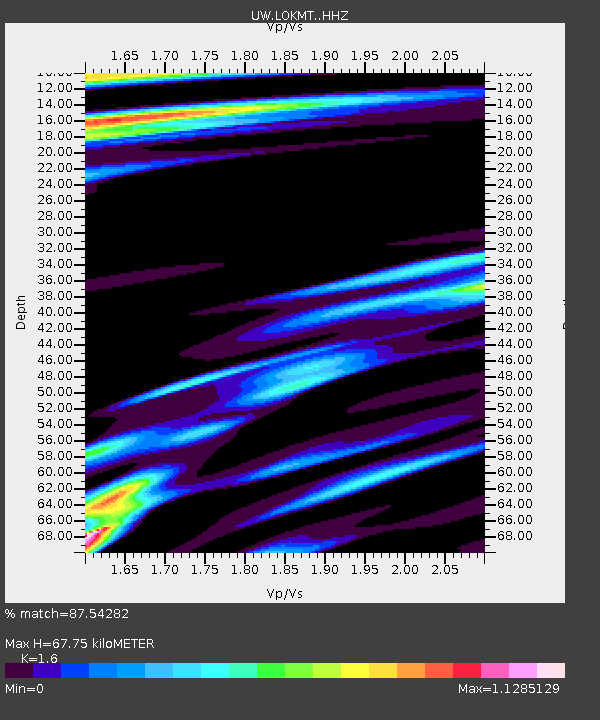
| Estimated Moho Depth: |
67.75 km |
| Estimated Crust Vp/Vs: |
1.60 |
| Assumed Crust Vp: |
6.597 km/s |
| Estimated Crust Vs: |
4.123 km/s |
| Estimated Crust Poisson's Ratio: |
0.18 |
|
| Radial Match: |
87.54282 % |
| Radial Bump: |
335 |
| Transverse Match: |
41.46739 % |
| Transverse Bump: |
400 |
| SOD ConfigId: |
28764291 |
| Insert Time: |
2022-11-03 12:38:14.639 +0000 |
| GWidth: |
2.5 |
| Max Bumps: |
400 |
| Tol: |
0.001 |
|

Signal To Noise
| Channel | StoN | STA | LTA |
| UW:LOKMT: :HHZ:20221020T12:05:46.330017Z | 11.084872 | 4.181445E-6 | 3.7722086E-7 |
| UW:LOKMT: :HHN:20221020T12:05:46.330017Z | 2.1599586 | 1.8967959E-6 | 8.781631E-7 |
| UW:LOKMT: :HHE:20221020T12:05:46.330017Z | 2.8337183 | 2.0330313E-6 | 7.1744296E-7 |
| Arrivals |
| Ps | 6.6 SECOND |
| PpPs | 25 SECOND |
| PsPs/PpSs | 32 SECOND |


