You are here: Home > Network List > UW - Pacific Northwest Regional Seismic Network Stations List
> Station DY2 Dyer Hill 2, WA, USA > Earthquake Result Viewer
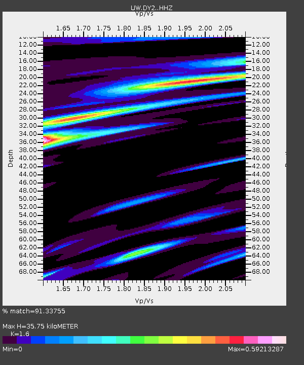
DY2 Dyer Hill 2, WA, USA - Earthquake Result Viewer
| Earthquake location: |
South Of Panama |
| Earthquake latitude/longitude: |
7.7/-82.3 |
| Earthquake time(UTC): |
2022/10/20 (293) 11:57:14 GMT |
| Earthquake Depth: |
10 km |
| Earthquake Magnitude: |
6.9 Mi |
| Earthquake Catalog/Contributor: |
NEIC PDE/at |
|
| Network: |
UW Pacific Northwest Regional Seismic Network |
| Station: |
DY2 Dyer Hill 2, WA, USA |
| Lat/Lon: |
47.99 N/119.77 W |
| Elevation: |
892 m |
|
| Distance: |
51.2 deg |
| Az: |
328.354 deg |
| Baz: |
129.283 deg |
| Ray Param: |
0.06759179 |
| Estimated Moho Depth: |
35.75 km |
| Estimated Crust Vp/Vs: |
1.60 |
| Assumed Crust Vp: |
6.419 km/s |
| Estimated Crust Vs: |
4.012 km/s |
| Estimated Crust Poisson's Ratio: |
0.18 |
|
| Radial Match: |
91.33755 % |
| Radial Bump: |
372 |
| Transverse Match: |
74.04683 % |
| Transverse Bump: |
400 |
| SOD ConfigId: |
28764291 |
| Insert Time: |
2022-11-03 12:38:19.892 +0000 |
| GWidth: |
2.5 |
| Max Bumps: |
400 |
| Tol: |
0.001 |
|

Signal To Noise
| Channel | StoN | STA | LTA |
| UW:DY2: :HHZ:20221020T12:05:46.190002Z | 9.077274 | 3.146568E-6 | 3.4664237E-7 |
| UW:DY2: :HHN:20221020T12:05:46.190002Z | 2.9157443 | 6.1616805E-7 | 2.1132443E-7 |
| UW:DY2: :HHE:20221020T12:05:46.190002Z | 7.968884 | 1.1743989E-6 | 1.4737307E-7 |
| Arrivals |
| Ps | 3.6 SECOND |
| PpPs | 14 SECOND |
| PsPs/PpSs | 17 SECOND |


