You are here: Home > Network List > XA95 - Missouri to Massachusetts Transect Stations List
> Station MM07 Sigel, Pennsylvania > Earthquake Result Viewer
MM07 Sigel, Pennsylvania - Earthquake Result Viewer
| Earthquake location: |
Near Coast Of Nicaragua |
| Earthquake latitude/longitude: |
11.7/-86.9 |
| Earthquake time(UTC): |
1996/03/03 (063) 14:55:11 GMT |
| Earthquake Depth: |
33 km |
| Earthquake Magnitude: |
5.7 MB, 6.5 MS, 6.8 UNKNOWN, 6.4 MS |
| Earthquake Catalog/Contributor: |
WHDF/NEIC |
|
| Network: |
XA Missouri to Massachusetts Transect |
| Station: |
MM07 Sigel, Pennsylvania |
| Lat/Lon: |
41.26 N/79.14 W |
| Elevation: |
518 m |
|
| Distance: |
30.3 deg |
| Az: |
11.597 deg |
| Baz: |
195.142 deg |
| Ray Param: |
0.079348974 |
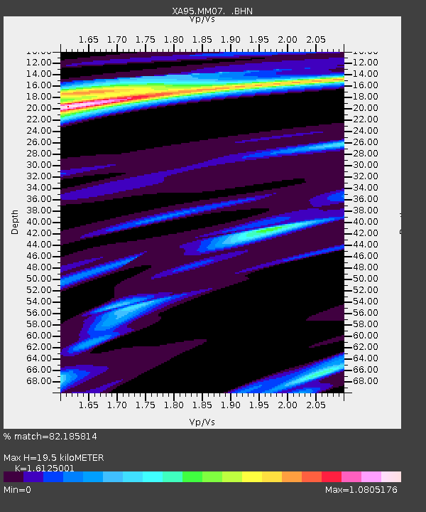
| Estimated Moho Depth: |
19.5 km |
| Estimated Crust Vp/Vs: |
1.61 |
| Assumed Crust Vp: |
6.121 km/s |
| Estimated Crust Vs: |
3.796 km/s |
| Estimated Crust Poisson's Ratio: |
0.19 |
|
| Radial Match: |
82.185814 % |
| Radial Bump: |
262 |
| Transverse Match: |
53.986603 % |
| Transverse Bump: |
400 |
| SOD ConfigId: |
6273 |
| Insert Time: |
2010-02-26 17:48:09.379 +0000 |
| GWidth: |
2.5 |
| Max Bumps: |
400 |
| Tol: |
0.001 |
|

Signal To Noise
| Channel | StoN | STA | LTA |
| XA:MM07: :BHN:19960303T15:00:49.366986Z | 1.3915834 | 1.2623573E-6 | 9.071373E-7 |
| XA:MM07: :BHE:19960303T15:00:49.366986Z | 0.9518995 | 4.230516E-7 | 4.4442885E-7 |
| XA:MM07: :BHZ:19960303T15:00:49.366986Z | 3.5947413 | 2.030079E-6 | 5.647358E-7 |
| Arrivals |
| Ps | 2.1 SECOND |
| PpPs | 7.7 SECOND |
| PsPs/PpSs | 9.8 SECOND |


