You are here: Home > Network List > UW - Pacific Northwest Regional Seismic Network Stations List
> Station DATON Dayton, WA, USA > Earthquake Result Viewer
DATON Dayton, WA, USA - Earthquake Result Viewer
| Earthquake location: |
South Of Panama |
| Earthquake latitude/longitude: |
7.7/-82.3 |
| Earthquake time(UTC): |
2022/10/20 (293) 11:57:14 GMT |
| Earthquake Depth: |
10 km |
| Earthquake Magnitude: |
6.9 Mi |
| Earthquake Catalog/Contributor: |
NEIC PDE/at |
|
| Network: |
UW Pacific Northwest Regional Seismic Network |
| Station: |
DATON Dayton, WA, USA |
| Lat/Lon: |
46.26 N/117.93 W |
| Elevation: |
815 m |
|
| Distance: |
49.1 deg |
| Az: |
327.679 deg |
| Baz: |
130.199 deg |
| Ray Param: |
0.06892315 |
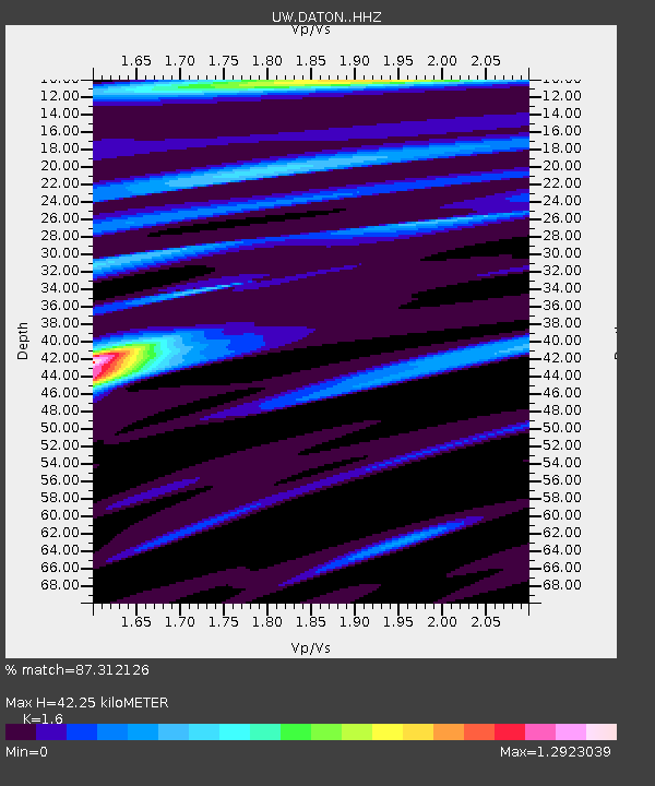
| Estimated Moho Depth: |
42.25 km |
| Estimated Crust Vp/Vs: |
1.60 |
| Assumed Crust Vp: |
6.571 km/s |
| Estimated Crust Vs: |
4.107 km/s |
| Estimated Crust Poisson's Ratio: |
0.18 |
|
| Radial Match: |
87.312126 % |
| Radial Bump: |
400 |
| Transverse Match: |
81.09656 % |
| Transverse Bump: |
290 |
| SOD ConfigId: |
28764291 |
| Insert Time: |
2022-11-03 12:39:30.672 +0000 |
| GWidth: |
2.5 |
| Max Bumps: |
400 |
| Tol: |
0.001 |
|

Signal To Noise
| Channel | StoN | STA | LTA |
| UW:DATON: :HHZ:20221020T12:05:30.519989Z | 9.191435 | 3.5428877E-6 | 3.8545537E-7 |
| UW:DATON: :HHN:20221020T12:05:30.519989Z | 2.5537019 | 7.2096856E-7 | 2.823229E-7 |
| UW:DATON: :HHE:20221020T12:05:30.519989Z | 3.2745728 | 9.099323E-7 | 2.7787817E-7 |
| Arrivals |
| Ps | 4.1 SECOND |
| PpPs | 16 SECOND |
| PsPs/PpSs | 20 SECOND |


