You are here: Home > Network List > WW - Idaho Seismic Network () Stations List
> Station BILL Emerald Creek, Idaho > Earthquake Result Viewer
BILL Emerald Creek, Idaho - Earthquake Result Viewer
| Earthquake location: |
South Of Panama |
| Earthquake latitude/longitude: |
7.7/-82.3 |
| Earthquake time(UTC): |
2022/10/20 (293) 11:57:14 GMT |
| Earthquake Depth: |
10 km |
| Earthquake Magnitude: |
6.9 Mi |
| Earthquake Catalog/Contributor: |
NEIC PDE/at |
|
| Network: |
WW Idaho Seismic Network () |
| Station: |
BILL Emerald Creek, Idaho |
| Lat/Lon: |
47.03 N/116.34 W |
| Elevation: |
866 m |
|
| Distance: |
48.8 deg |
| Az: |
329.405 deg |
| Baz: |
132.484 deg |
| Ray Param: |
0.069137104 |
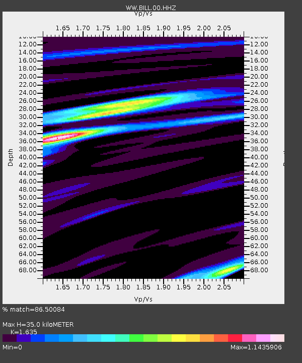
| Estimated Moho Depth: |
35.0 km |
| Estimated Crust Vp/Vs: |
1.63 |
| Assumed Crust Vp: |
6.571 km/s |
| Estimated Crust Vs: |
4.019 km/s |
| Estimated Crust Poisson's Ratio: |
0.20 |
|
| Radial Match: |
86.50084 % |
| Radial Bump: |
361 |
| Transverse Match: |
54.174786 % |
| Transverse Bump: |
400 |
| SOD ConfigId: |
28764291 |
| Insert Time: |
2022-11-03 12:41:13.604 +0000 |
| GWidth: |
2.5 |
| Max Bumps: |
400 |
| Tol: |
0.001 |
|
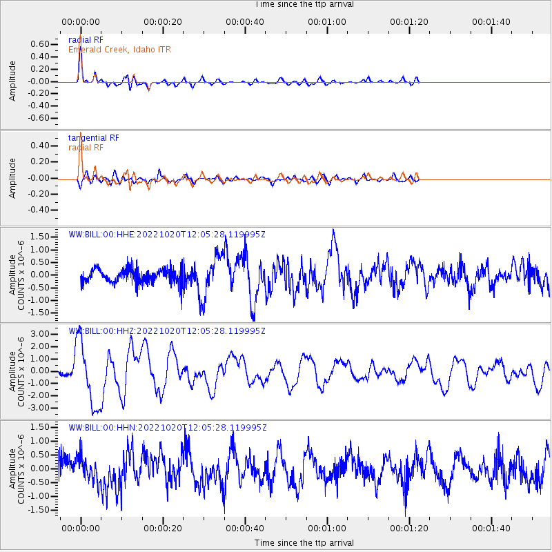
Signal To Noise
| Channel | StoN | STA | LTA |
| WW:BILL:00:HHZ:20221020T12:05:28.119995Z | 10.491353 | 2.704265E-6 | 2.5776131E-7 |
| WW:BILL:00:HHN:20221020T12:05:28.119995Z | 1.3052998 | 4.4164142E-7 | 3.383448E-7 |
| WW:BILL:00:HHE:20221020T12:05:28.119995Z | 3.0906193 | 8.53833E-7 | 2.76266E-7 |
| Arrivals |
| Ps | 3.6 SECOND |
| PpPs | 13 SECOND |
| PsPs/PpSs | 17 SECOND |


