You are here: Home > Network List > XA95 - Missouri to Massachusetts Transect Stations List
> Station MM07 Sigel, Pennsylvania > Earthquake Result Viewer
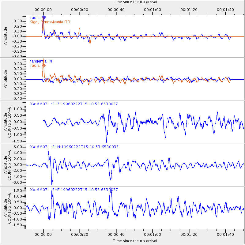
MM07 Sigel, Pennsylvania - Earthquake Result Viewer
*The percent match for this event was below the threshold and hence no stack was calculated.
| Earthquake location: |
Kuril Islands |
| Earthquake latitude/longitude: |
45.2/148.6 |
| Earthquake time(UTC): |
1996/02/22 (053) 14:59:09 GMT |
| Earthquake Depth: |
133 km |
| Earthquake Magnitude: |
6.2 MB, 6.3 UNKNOWN, 6.3 MW |
| Earthquake Catalog/Contributor: |
WHDF/NEIC |
|
| Network: |
XA Missouri to Massachusetts Transect |
| Station: |
MM07 Sigel, Pennsylvania |
| Lat/Lon: |
41.26 N/79.14 W |
| Elevation: |
518 m |
|
| Distance: |
83.9 deg |
| Az: |
34.106 deg |
| Baz: |
328.282 deg |
| Ray Param: |
$rayparam |
*The percent match for this event was below the threshold and hence was not used in the summary stack. |
|
| Radial Match: |
79.745895 % |
| Radial Bump: |
400 |
| Transverse Match: |
64.46382 % |
| Transverse Bump: |
400 |
| SOD ConfigId: |
4480 |
| Insert Time: |
2010-02-26 17:48:14.413 +0000 |
| GWidth: |
2.5 |
| Max Bumps: |
400 |
| Tol: |
0.001 |
|
Signal To Noise
| Channel | StoN | STA | LTA |
| XA:MM07: :BHN:19960222T15:10:53.653003Z | 7.3772726 | 2.316129E-6 | 3.1395464E-7 |
| XA:MM07: :BHE:19960222T15:10:53.653003Z | 2.036819 | 5.5725263E-7 | 2.7358968E-7 |
| XA:MM07: :BHZ:19960222T15:10:53.653003Z | 2.92077 | 4.89174E-7 | 1.6748119E-7 |
| Arrivals |
| Ps | |
| PpPs | |
| PsPs/PpSs | |


