You are here: Home > Network List > IU - Global Seismograph Network (GSN - IRIS/USGS) Stations List
> Station SLBS Sierra la Laguna Baja California Sur, Mexico > Earthquake Result Viewer
SLBS Sierra la Laguna Baja California Sur, Mexico - Earthquake Result Viewer
| Earthquake location: |
Chile-Bolivia Border Region |
| Earthquake latitude/longitude: |
-22.0/-68.7 |
| Earthquake time(UTC): |
2022/10/23 (296) 02:08:29 GMT |
| Earthquake Depth: |
106 km |
| Earthquake Magnitude: |
5.1 Mww |
| Earthquake Catalog/Contributor: |
NEIC PDE/us |
|
| Network: |
IU Global Seismograph Network (GSN - IRIS/USGS) |
| Station: |
SLBS Sierra la Laguna Baja California Sur, Mexico |
| Lat/Lon: |
23.69 N/109.94 W |
| Elevation: |
825 m |
|
| Distance: |
60.5 deg |
| Az: |
316.095 deg |
| Baz: |
135.396 deg |
| Ray Param: |
0.0611703 |
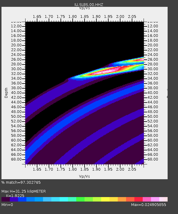
| Estimated Moho Depth: |
31.25 km |
| Estimated Crust Vp/Vs: |
1.92 |
| Assumed Crust Vp: |
6.183 km/s |
| Estimated Crust Vs: |
3.216 km/s |
| Estimated Crust Poisson's Ratio: |
0.31 |
|
| Radial Match: |
97.302765 % |
| Radial Bump: |
69 |
| Transverse Match: |
94.44724 % |
| Transverse Bump: |
151 |
| SOD ConfigId: |
28764291 |
| Insert Time: |
2022-11-06 02:21:37.923 +0000 |
| GWidth: |
2.5 |
| Max Bumps: |
400 |
| Tol: |
0.001 |
|

Signal To Noise
| Channel | StoN | STA | LTA |
| IU:SLBS:00:HHZ:20221023T02:17:57.768022Z | 7.5781336 | 1.696057E-7 | 2.2380933E-8 |
| IU:SLBS:00:HH1:20221023T02:17:57.768022Z | 7.422126 | 5.8132684E-8 | 7.83235E-9 |
| IU:SLBS:00:HH2:20221023T02:17:57.768022Z | 9.088727 | 5.847846E-8 | 6.434175E-9 |
| Arrivals |
| Ps | 4.8 SECOND |
| PpPs | 14 SECOND |
| PsPs/PpSs | 19 SECOND |


