You are here: Home > Network List > US - United States National Seismic Network Stations List
> Station HAWA Hanford, Washington, USA > Earthquake Result Viewer
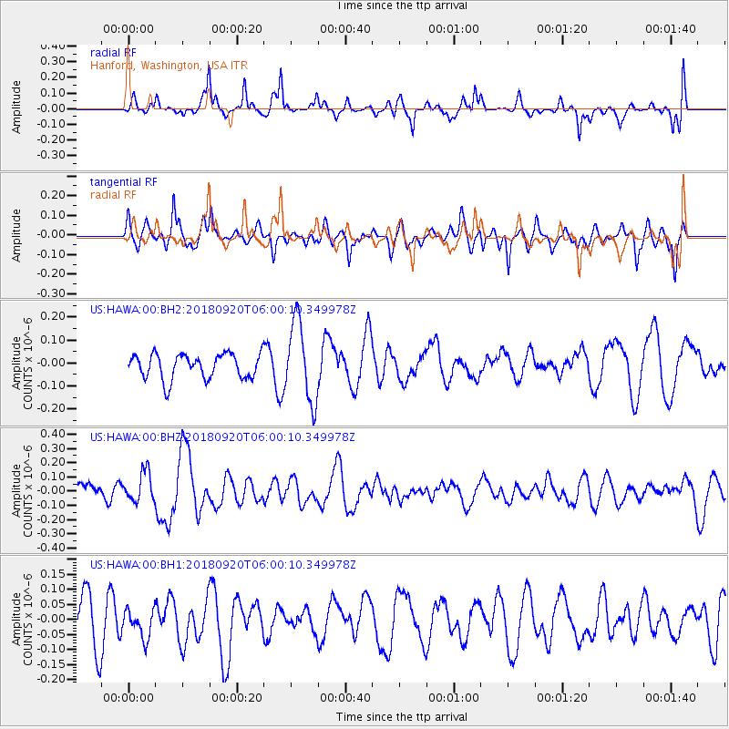
HAWA Hanford, Washington, USA - Earthquake Result Viewer
*The percent match for this event was below the threshold and hence no stack was calculated.
| Earthquake location: |
Solomon Islands |
| Earthquake latitude/longitude: |
-9.0/158.3 |
| Earthquake time(UTC): |
2018/09/20 (263) 05:47:37 GMT |
| Earthquake Depth: |
10 km |
| Earthquake Magnitude: |
5.5 mb |
| Earthquake Catalog/Contributor: |
NEIC PDE/us |
|
| Network: |
US United States National Seismic Network |
| Station: |
HAWA Hanford, Washington, USA |
| Lat/Lon: |
46.39 N/119.53 W |
| Elevation: |
364 m |
|
| Distance: |
91.1 deg |
| Az: |
43.297 deg |
| Baz: |
258.173 deg |
| Ray Param: |
$rayparam |
*The percent match for this event was below the threshold and hence was not used in the summary stack. |
|
| Radial Match: |
66.503 % |
| Radial Bump: |
400 |
| Transverse Match: |
61.49089 % |
| Transverse Bump: |
400 |
| SOD ConfigId: |
2963291 |
| Insert Time: |
2018-10-04 05:58:18.838 +0000 |
| GWidth: |
2.5 |
| Max Bumps: |
400 |
| Tol: |
0.001 |
|
Signal To Noise
| Channel | StoN | STA | LTA |
| US:HAWA:00:BHZ:20180920T06:00:10.349978Z | 0.966086 | 1.0439318E-7 | 1.08057854E-7 |
| US:HAWA:00:BH1:20180920T06:00:10.349978Z | 0.47901776 | 4.821665E-8 | 1.00657324E-7 |
| US:HAWA:00:BH2:20180920T06:00:10.349978Z | 3.2296095 | 1.7391172E-7 | 5.3849146E-8 |
| Arrivals |
| Ps | |
| PpPs | |
| PsPs/PpSs | |


