You are here: Home > Network List > GS - US Geological Survey Networks Stations List
> Station KAN01 Ward Farm, Argonia, KS, USA > Earthquake Result Viewer
KAN01 Ward Farm, Argonia, KS, USA - Earthquake Result Viewer
| Earthquake location: |
Fiji Islands |
| Earthquake latitude/longitude: |
-18.3/179.3 |
| Earthquake time(UTC): |
2018/09/06 (249) 15:56:41 GMT |
| Earthquake Depth: |
657 km |
| Earthquake Magnitude: |
5.7 mb |
| Earthquake Catalog/Contributor: |
NEIC PDE/us |
|
| Network: |
GS US Geological Survey Networks |
| Station: |
KAN01 Ward Farm, Argonia, KS, USA |
| Lat/Lon: |
37.15 N/97.76 W |
| Elevation: |
360 m |
|
| Distance: |
95.4 deg |
| Az: |
52.788 deg |
| Baz: |
251.281 deg |
| Ray Param: |
0.04007155 |
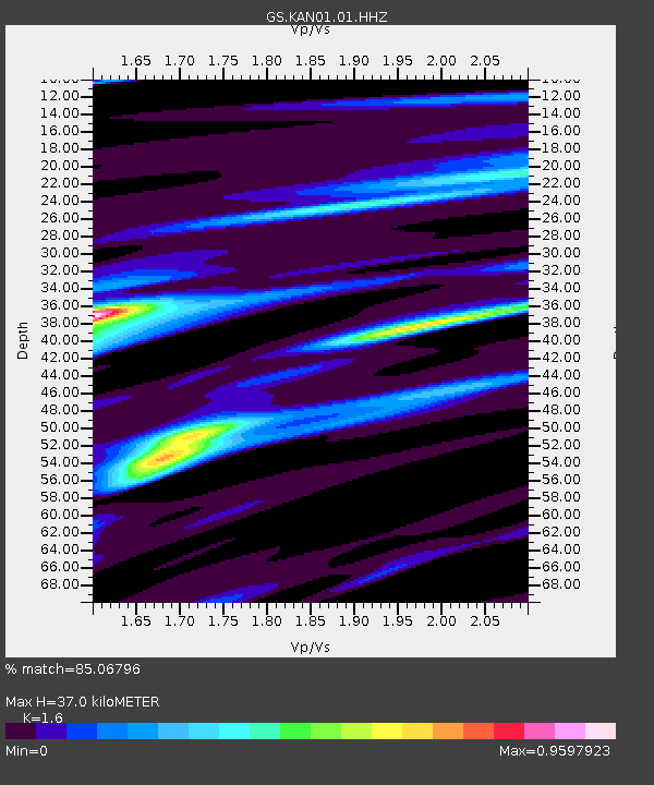
| Estimated Moho Depth: |
37.0 km |
| Estimated Crust Vp/Vs: |
1.60 |
| Assumed Crust Vp: |
6.483 km/s |
| Estimated Crust Vs: |
4.052 km/s |
| Estimated Crust Poisson's Ratio: |
0.18 |
|
| Radial Match: |
85.06796 % |
| Radial Bump: |
400 |
| Transverse Match: |
45.951847 % |
| Transverse Bump: |
400 |
| SOD ConfigId: |
2963291 |
| Insert Time: |
2018-10-04 15:42:18.820 +0000 |
| GWidth: |
2.5 |
| Max Bumps: |
400 |
| Tol: |
0.001 |
|

Signal To Noise
| Channel | StoN | STA | LTA |
| GS:KAN01:01:HHZ:20180906T16:08:25.885024Z | 2.738958 | 7.864377E-6 | 2.8713023E-6 |
| GS:KAN01:01:HHN:20180906T16:08:25.885024Z | 0.86976224 | 1.8511043E-6 | 2.1282879E-6 |
| GS:KAN01:01:HHE:20180906T16:08:25.885024Z | 2.5843468 | 5.13313E-6 | 1.9862389E-6 |
| Arrivals |
| Ps | 3.5 SECOND |
| PpPs | 15 SECOND |
| PsPs/PpSs | 18 SECOND |


