You are here: Home > Network List > XA95 - Missouri to Massachusetts Transect Stations List
> Station MM07 Sigel, Pennsylvania > Earthquake Result Viewer
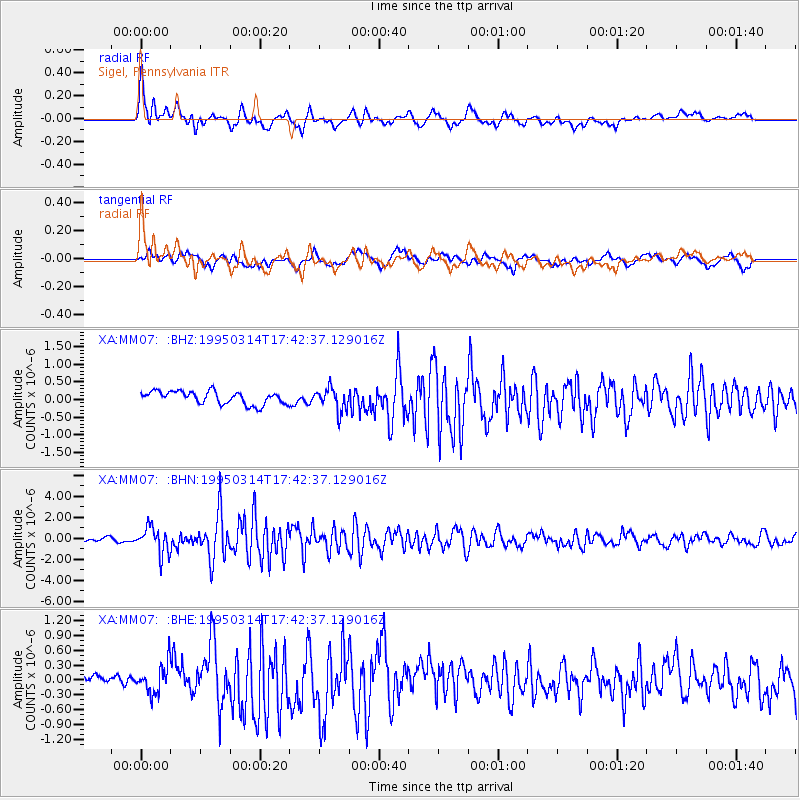
MM07 Sigel, Pennsylvania - Earthquake Result Viewer
*The percent match for this event was below the threshold and hence no stack was calculated.
| Earthquake location: |
Alaska Peninsula |
| Earthquake latitude/longitude: |
54.8/-161.3 |
| Earthquake time(UTC): |
1995/03/14 (073) 17:33:50 GMT |
| Earthquake Depth: |
33 km |
| Earthquake Magnitude: |
6.1 MB, 5.9 MS, 6.2 UNKNOWN, 5.5 ML |
| Earthquake Catalog/Contributor: |
WHDF/NEIC |
|
| Network: |
XA Missouri to Massachusetts Transect |
| Station: |
MM07 Sigel, Pennsylvania |
| Lat/Lon: |
41.26 N/79.14 W |
| Elevation: |
518 m |
|
| Distance: |
53.5 deg |
| Az: |
68.342 deg |
| Baz: |
314.448 deg |
| Ray Param: |
$rayparam |
*The percent match for this event was below the threshold and hence was not used in the summary stack. |
|
| Radial Match: |
78.26416 % |
| Radial Bump: |
400 |
| Transverse Match: |
61.422043 % |
| Transverse Bump: |
400 |
| SOD ConfigId: |
4480 |
| Insert Time: |
2010-02-26 17:48:24.158 +0000 |
| GWidth: |
2.5 |
| Max Bumps: |
400 |
| Tol: |
0.001 |
|
Signal To Noise
| Channel | StoN | STA | LTA |
| XA:MM07: :BHN:19950314T17:42:37.129016Z | 5.7751026 | 1.2817602E-6 | 2.219459E-7 |
| XA:MM07: :BHE:19950314T17:42:37.129016Z | 1.3260882 | 3.1211772E-7 | 2.3536725E-7 |
| XA:MM07: :BHZ:19950314T17:42:37.129016Z | 1.815861 | 3.2979955E-7 | 1.8162159E-7 |
| Arrivals |
| Ps | |
| PpPs | |
| PsPs/PpSs | |


