You are here: Home > Network List > IU - Global Seismograph Network (GSN - IRIS/USGS) Stations List
> Station PAYG Puerto Ayora, Galapagos Islands > Earthquake Result Viewer
PAYG Puerto Ayora, Galapagos Islands - Earthquake Result Viewer
| Earthquake location: |
Fiji Islands |
| Earthquake latitude/longitude: |
-18.3/179.3 |
| Earthquake time(UTC): |
2018/09/06 (249) 15:56:41 GMT |
| Earthquake Depth: |
657 km |
| Earthquake Magnitude: |
5.7 mb |
| Earthquake Catalog/Contributor: |
NEIC PDE/us |
|
| Network: |
IU Global Seismograph Network (GSN - IRIS/USGS) |
| Station: |
PAYG Puerto Ayora, Galapagos Islands |
| Lat/Lon: |
0.67 S/90.29 W |
| Elevation: |
270 m |
|
| Distance: |
90.2 deg |
| Az: |
90.76 deg |
| Baz: |
251.829 deg |
| Ray Param: |
0.04139155 |
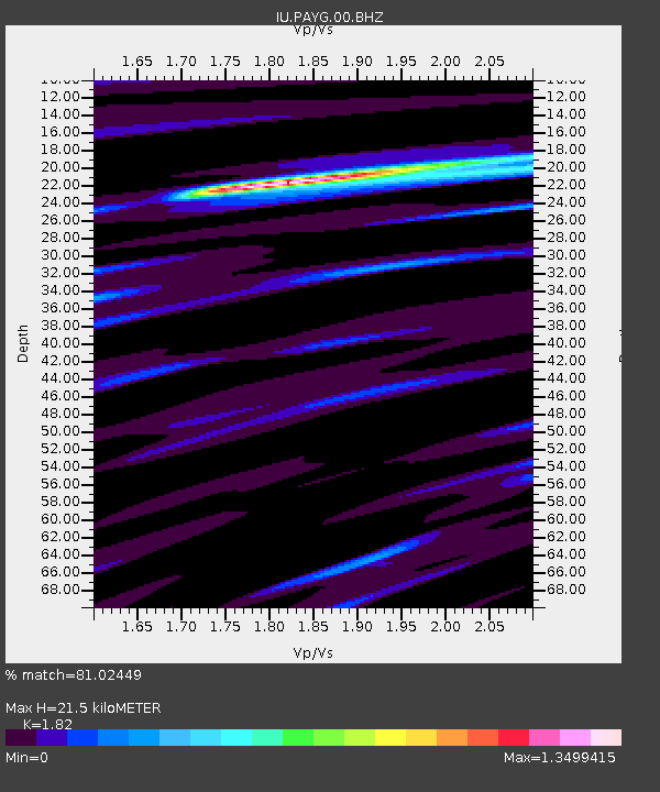
| Estimated Moho Depth: |
21.5 km |
| Estimated Crust Vp/Vs: |
1.82 |
| Assumed Crust Vp: |
4.802 km/s |
| Estimated Crust Vs: |
2.638 km/s |
| Estimated Crust Poisson's Ratio: |
0.28 |
|
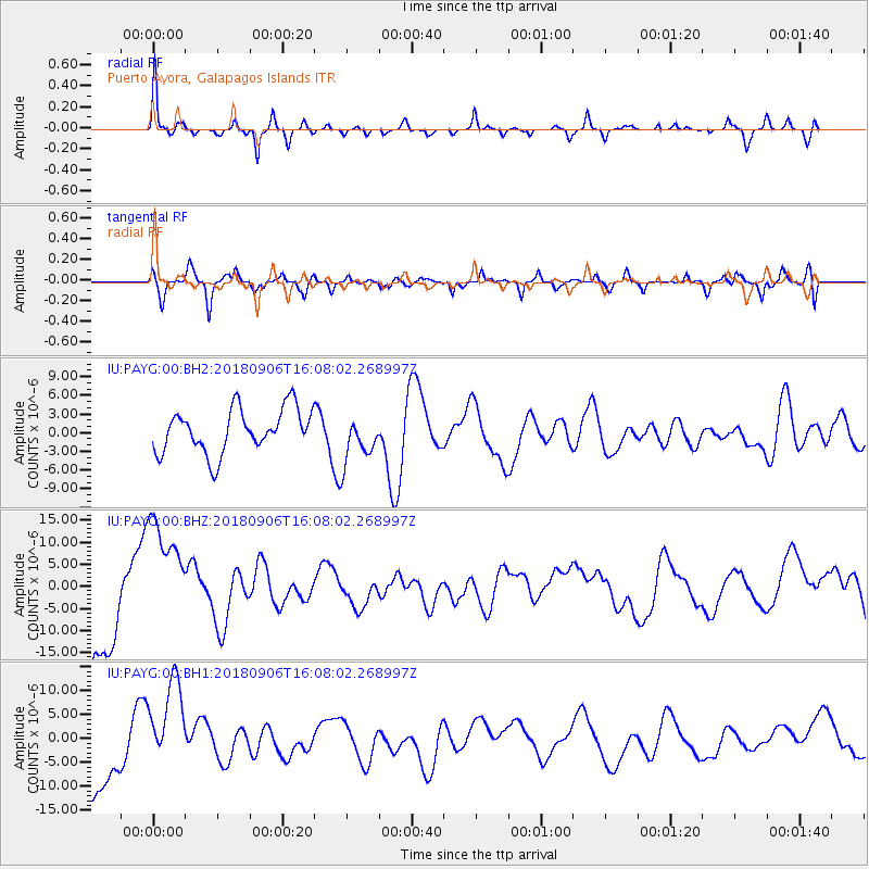
| Radial Match: |
81.02449 % |
| Radial Bump: |
255 |
| Transverse Match: |
65.35099 % |
| Transverse Bump: |
400 |
| SOD ConfigId: |
2963291 |
| Insert Time: |
2018-10-04 15:43:14.236 +0000 |
| GWidth: |
2.5 |
| Max Bumps: |
400 |
| Tol: |
0.001 |
|
Signal To Noise
| Channel | StoN | STA | LTA |
| IU:PAYG:00:BHZ:20180906T16:08:02.268997Z | 1.5550482 | 1.3892648E-5 | 8.933902E-6 |
| IU:PAYG:00:BH1:20180906T16:08:02.268997Z | 1.6904941 | 9.90284E-6 | 5.8579562E-6 |
| IU:PAYG:00:BH2:20180906T16:08:02.268997Z | 1.0997247 | 3.8469047E-6 | 3.498062E-6 |
| Arrivals |
| Ps | 3.7 SECOND |
| PpPs | 12 SECOND |
| PsPs/PpSs | 16 SECOND |


