You are here: Home > Network List > IW - Intermountain West Stations List
> Station MOOW Moose Ponds, Wyoming, USA > Earthquake Result Viewer
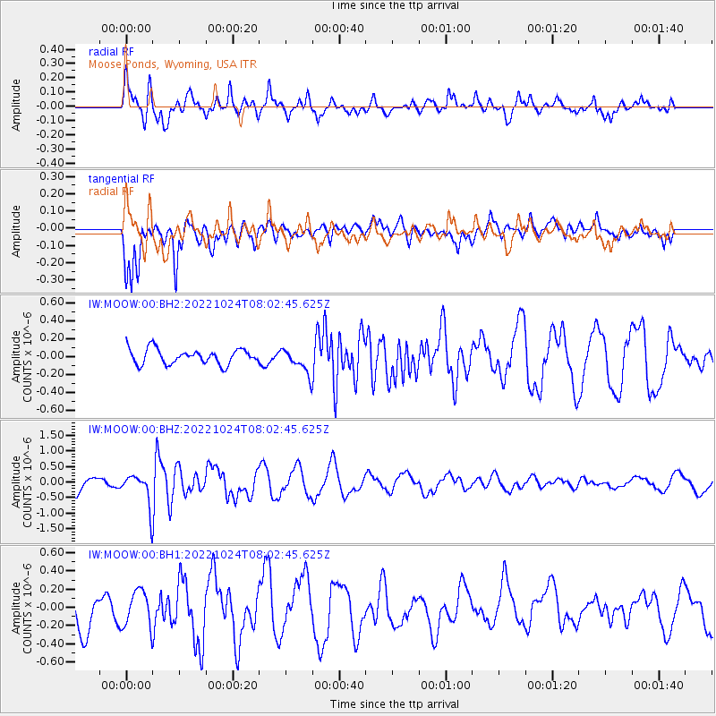
MOOW Moose Ponds, Wyoming, USA - Earthquake Result Viewer
*The percent match for this event was below the threshold and hence no stack was calculated.
| Earthquake location: |
Tonga Islands |
| Earthquake latitude/longitude: |
-15.5/-173.1 |
| Earthquake time(UTC): |
2022/10/24 (297) 07:51:10 GMT |
| Earthquake Depth: |
114 km |
| Earthquake Magnitude: |
5.9 Mi |
| Earthquake Catalog/Contributor: |
NEIC PDE/pt |
|
| Network: |
IW Intermountain West |
| Station: |
MOOW Moose Ponds, Wyoming, USA |
| Lat/Lon: |
43.75 N/110.74 W |
| Elevation: |
2128 m |
|
| Distance: |
81.9 deg |
| Az: |
40.44 deg |
| Baz: |
239.657 deg |
| Ray Param: |
$rayparam |
*The percent match for this event was below the threshold and hence was not used in the summary stack. |
|
| Radial Match: |
66.858604 % |
| Radial Bump: |
400 |
| Transverse Match: |
83.61568 % |
| Transverse Bump: |
400 |
| SOD ConfigId: |
28764291 |
| Insert Time: |
2022-11-07 08:10:21.813 +0000 |
| GWidth: |
2.5 |
| Max Bumps: |
400 |
| Tol: |
0.001 |
|
Signal To Noise
| Channel | StoN | STA | LTA |
| IW:MOOW:00:BHZ:20221024T08:02:45.625Z | 1.8840952 | 5.2342347E-7 | 2.7781158E-7 |
| IW:MOOW:00:BH1:20221024T08:02:45.625Z | 0.65803695 | 1.9653062E-7 | 2.98662E-7 |
| IW:MOOW:00:BH2:20221024T08:02:45.625Z | 1.6590639 | 1.3921235E-7 | 8.391017E-8 |
| Arrivals |
| Ps | |
| PpPs | |
| PsPs/PpSs | |


