You are here: Home > Network List > TX - Texas Seismological Network Stations List
> Station WTFS Witchita Falls > Earthquake Result Viewer
WTFS Witchita Falls - Earthquake Result Viewer

| Earthquake location: |
Fiji Islands |
| Earthquake latitude/longitude: |
-18.3/179.3 |
| Earthquake time(UTC): |
2018/09/06 (249) 15:56:41 GMT |
| Earthquake Depth: |
657 km |
| Earthquake Magnitude: |
5.7 mb |
| Earthquake Catalog/Contributor: |
NEIC PDE/us |
|
| Network: |
TX Texas Seismological Network |
| Station: |
WTFS Witchita Falls |
| Lat/Lon: |
33.77 N/98.46 W |
| Elevation: |
277 m |
|
| Distance: |
93.7 deg |
| Az: |
55.804 deg |
| Baz: |
250.633 deg |
| Ray Param: |
0.04055571 |
| Estimated Moho Depth: |
24.25 km |
| Estimated Crust Vp/Vs: |
2.08 |
| Assumed Crust Vp: |
6.426 km/s |
| Estimated Crust Vs: |
3.086 km/s |
| Estimated Crust Poisson's Ratio: |
0.35 |
|
| Radial Match: |
81.93481 % |
| Radial Bump: |
349 |
| Transverse Match: |
53.569397 % |
| Transverse Bump: |
400 |
| SOD ConfigId: |
2963291 |
| Insert Time: |
2018-10-04 15:44:39.340 +0000 |
| GWidth: |
2.5 |
| Max Bumps: |
400 |
| Tol: |
0.001 |
|
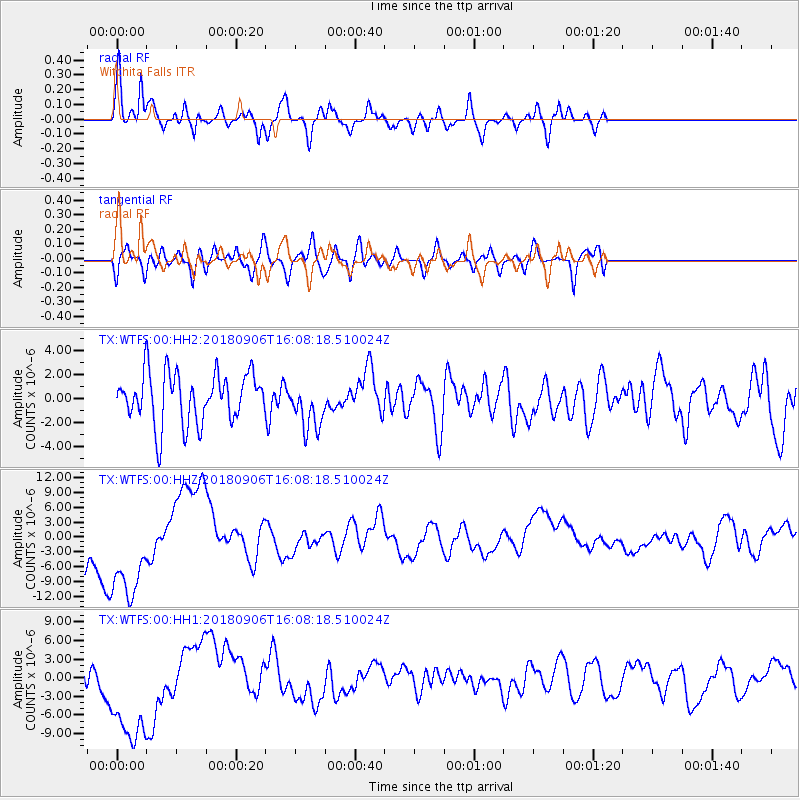
Signal To Noise
| Channel | StoN | STA | LTA |
| TX:WTFS:00:HHZ:20180906T16:08:18.510024Z | 2.8300064 | 1.0846187E-5 | 3.8325666E-6 |
| TX:WTFS:00:HH1:20180906T16:08:18.510024Z | 2.984928 | 9.279462E-6 | 3.1087727E-6 |
| TX:WTFS:00:HH2:20180906T16:08:18.510024Z | 0.96025825 | 2.015511E-6 | 2.0989262E-6 |
| Arrivals |
| Ps | 4.2 SECOND |
| PpPs | 11 SECOND |
| PsPs/PpSs | 16 SECOND |


