You are here: Home > Network List > WY - Yellowstone Wyoming Seismic Network Stations List
> Station YHH Holmes Hill, YNP, WY, USA > Earthquake Result Viewer
YHH Holmes Hill, YNP, WY, USA - Earthquake Result Viewer
| Earthquake location: |
Fiji Islands |
| Earthquake latitude/longitude: |
-18.3/179.3 |
| Earthquake time(UTC): |
2018/09/06 (249) 15:56:41 GMT |
| Earthquake Depth: |
657 km |
| Earthquake Magnitude: |
5.7 mb |
| Earthquake Catalog/Contributor: |
NEIC PDE/us |
|
| Network: |
WY Yellowstone Wyoming Seismic Network |
| Station: |
YHH Holmes Hill, YNP, WY, USA |
| Lat/Lon: |
44.79 N/110.85 W |
| Elevation: |
2717 m |
|
| Distance: |
89.2 deg |
| Az: |
41.95 deg |
| Baz: |
243.123 deg |
| Ray Param: |
0.041555103 |
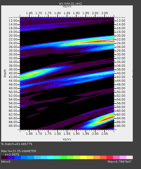
| Estimated Moho Depth: |
22.25 km |
| Estimated Crust Vp/Vs: |
2.10 |
| Assumed Crust Vp: |
6.35 km/s |
| Estimated Crust Vs: |
3.027 km/s |
| Estimated Crust Poisson's Ratio: |
0.35 |
|
| Radial Match: |
83.465775 % |
| Radial Bump: |
400 |
| Transverse Match: |
74.637596 % |
| Transverse Bump: |
400 |
| SOD ConfigId: |
2963291 |
| Insert Time: |
2018-10-04 15:46:05.869 +0000 |
| GWidth: |
2.5 |
| Max Bumps: |
400 |
| Tol: |
0.001 |
|
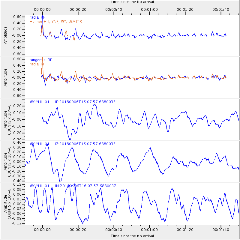
Signal To Noise
| Channel | StoN | STA | LTA |
| WY:YHH:01:HHZ:20180906T16:07:57.688003Z | 1.3332961 | 2.9942336E-7 | 2.245738E-7 |
| WY:YHH:01:HHN:20180906T16:07:57.688003Z | 1.1218902 | 5.8247586E-8 | 5.191915E-8 |
| WY:YHH:01:HHE:20180906T16:07:57.688003Z | 1.270707 | 1.4988336E-7 | 1.1795273E-7 |
| Arrivals |
| Ps | 3.9 SECOND |
| PpPs | 11 SECOND |
| PsPs/PpSs | 15 SECOND |


