You are here: Home > Network List > WY - Yellowstone Wyoming Seismic Network Stations List
> Station YNE Northeast Entrance, YNP, WY, USA > Earthquake Result Viewer
YNE Northeast Entrance, YNP, WY, USA - Earthquake Result Viewer
| Earthquake location: |
Fiji Islands |
| Earthquake latitude/longitude: |
-18.3/179.3 |
| Earthquake time(UTC): |
2018/09/06 (249) 15:56:41 GMT |
| Earthquake Depth: |
657 km |
| Earthquake Magnitude: |
5.7 mb |
| Earthquake Catalog/Contributor: |
NEIC PDE/us |
|
| Network: |
WY Yellowstone Wyoming Seismic Network |
| Station: |
YNE Northeast Entrance, YNP, WY, USA |
| Lat/Lon: |
45.01 N/110.01 W |
| Elevation: |
2343 m |
|
| Distance: |
89.8 deg |
| Az: |
42.022 deg |
| Baz: |
243.717 deg |
| Ray Param: |
0.04146014 |
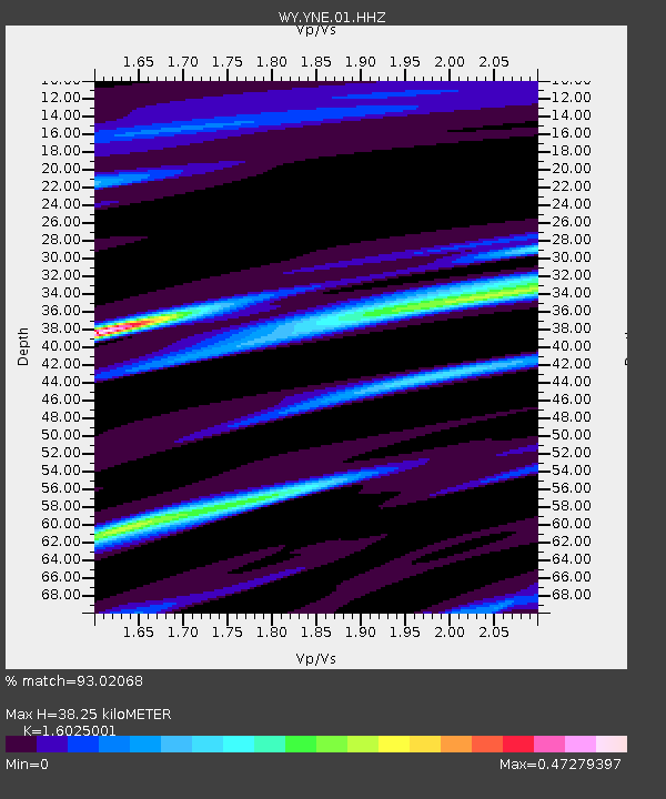
| Estimated Moho Depth: |
38.25 km |
| Estimated Crust Vp/Vs: |
1.60 |
| Assumed Crust Vp: |
6.35 km/s |
| Estimated Crust Vs: |
3.963 km/s |
| Estimated Crust Poisson's Ratio: |
0.18 |
|
| Radial Match: |
93.02068 % |
| Radial Bump: |
224 |
| Transverse Match: |
61.32975 % |
| Transverse Bump: |
400 |
| SOD ConfigId: |
2963291 |
| Insert Time: |
2018-10-04 15:46:10.212 +0000 |
| GWidth: |
2.5 |
| Max Bumps: |
400 |
| Tol: |
0.001 |
|

Signal To Noise
| Channel | StoN | STA | LTA |
| WY:YNE:01:HHZ:20180906T16:08:00.59999Z | 1.364123 | 2.740803E-7 | 2.0092052E-7 |
| WY:YNE:01:HHN:20180906T16:08:00.59999Z | 0.6417199 | 3.878853E-8 | 6.044465E-8 |
| WY:YNE:01:HHE:20180906T16:08:00.59999Z | 1.1603886 | 1.2093416E-7 | 1.0421867E-7 |
| Arrivals |
| Ps | 3.7 SECOND |
| PpPs | 15 SECOND |
| PsPs/PpSs | 19 SECOND |


