You are here: Home > Network List > AV - Alaska Volcano Observatory Stations List
> Station MAPS Pakushin Southeast, Makushin Volcano, Alaska > Earthquake Result Viewer
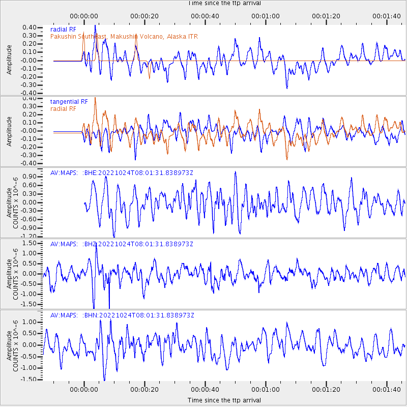
MAPS Pakushin Southeast, Makushin Volcano, Alaska - Earthquake Result Viewer
*The percent match for this event was below the threshold and hence no stack was calculated.
| Earthquake location: |
Tonga Islands |
| Earthquake latitude/longitude: |
-15.2/-173.2 |
| Earthquake time(UTC): |
2022/10/24 (297) 07:50:58 GMT |
| Earthquake Depth: |
10 km |
| Earthquake Magnitude: |
5.6 mww |
| Earthquake Catalog/Contributor: |
NEIC PDE/us |
|
| Network: |
AV Alaska Volcano Observatory |
| Station: |
MAPS Pakushin Southeast, Makushin Volcano, Alaska |
| Lat/Lon: |
53.81 N/166.94 W |
| Elevation: |
333 m |
|
| Distance: |
68.9 deg |
| Az: |
3.974 deg |
| Baz: |
186.479 deg |
| Ray Param: |
$rayparam |
*The percent match for this event was below the threshold and hence was not used in the summary stack. |
|
| Radial Match: |
58.524384 % |
| Radial Bump: |
400 |
| Transverse Match: |
41.260826 % |
| Transverse Bump: |
400 |
| SOD ConfigId: |
28764291 |
| Insert Time: |
2022-11-07 08:33:15.577 +0000 |
| GWidth: |
2.5 |
| Max Bumps: |
400 |
| Tol: |
0.001 |
|
Signal To Noise
| Channel | StoN | STA | LTA |
| AV:MAPS: :BHZ:20221024T08:01:31.838973Z | 2.3271377 | 7.2461546E-7 | 3.1137628E-7 |
| AV:MAPS: :BHN:20221024T08:01:31.838973Z | 0.7468365 | 3.1409974E-7 | 4.205736E-7 |
| AV:MAPS: :BHE:20221024T08:01:31.838973Z | 0.7108979 | 3.35109E-7 | 4.7138835E-7 |
| Arrivals |
| Ps | |
| PpPs | |
| PsPs/PpSs | |


