You are here: Home > Network List > IU - Global Seismograph Network (GSN - IRIS/USGS) Stations List
> Station CTAO Charters Towers, Australia > Earthquake Result Viewer
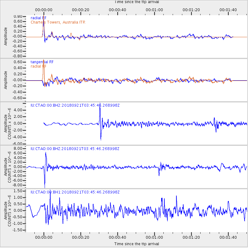
CTAO Charters Towers, Australia - Earthquake Result Viewer
*The percent match for this event was below the threshold and hence no stack was calculated.
| Earthquake location: |
Fiji Islands Region |
| Earthquake latitude/longitude: |
-17.9/-179.9 |
| Earthquake time(UTC): |
2018/09/21 (264) 03:40:40 GMT |
| Earthquake Depth: |
653 km |
| Earthquake Magnitude: |
5.9 Mww |
| Earthquake Catalog/Contributor: |
NEIC PDE/us |
|
| Network: |
IU Global Seismograph Network (GSN - IRIS/USGS) |
| Station: |
CTAO Charters Towers, Australia |
| Lat/Lon: |
20.09 S/146.25 E |
| Elevation: |
357 m |
|
| Distance: |
32.0 deg |
| Az: |
260.62 deg |
| Baz: |
91.851 deg |
| Ray Param: |
$rayparam |
*The percent match for this event was below the threshold and hence was not used in the summary stack. |
|
| Radial Match: |
75.84908 % |
| Radial Bump: |
348 |
| Transverse Match: |
61.803146 % |
| Transverse Bump: |
400 |
| SOD ConfigId: |
2963291 |
| Insert Time: |
2018-10-05 03:52:28.560 +0000 |
| GWidth: |
2.5 |
| Max Bumps: |
400 |
| Tol: |
0.001 |
|
Signal To Noise
| Channel | StoN | STA | LTA |
| IU:CTAO:00:BHZ:20180921T03:45:46.268998Z | 10.854705 | 2.691822E-6 | 2.4798663E-7 |
| IU:CTAO:00:BH1:20180921T03:45:46.268998Z | 2.636218 | 5.8123294E-7 | 2.2047983E-7 |
| IU:CTAO:00:BH2:20180921T03:45:46.268998Z | 9.001487 | 1.8301631E-6 | 2.0331787E-7 |
| Arrivals |
| Ps | |
| PpPs | |
| PsPs/PpSs | |


