You are here: Home > Network List > US - United States National Seismic Network Stations List
> Station AMTX Amarillo, Texas, USA > Earthquake Result Viewer
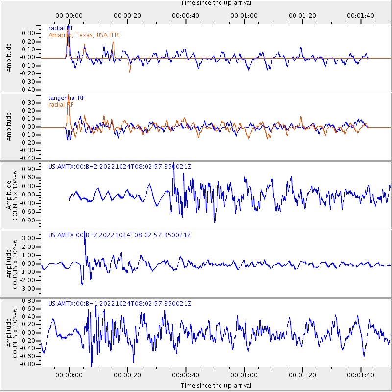
AMTX Amarillo, Texas, USA - Earthquake Result Viewer
*The percent match for this event was below the threshold and hence no stack was calculated.
| Earthquake location: |
Tonga Islands |
| Earthquake latitude/longitude: |
-15.2/-173.2 |
| Earthquake time(UTC): |
2022/10/24 (297) 07:50:58 GMT |
| Earthquake Depth: |
10 km |
| Earthquake Magnitude: |
5.6 mww |
| Earthquake Catalog/Contributor: |
NEIC PDE/us |
|
| Network: |
US United States National Seismic Network |
| Station: |
AMTX Amarillo, Texas, USA |
| Lat/Lon: |
34.53 N/101.41 W |
| Elevation: |
1010 m |
|
| Distance: |
84.1 deg |
| Az: |
52.035 deg |
| Baz: |
247.223 deg |
| Ray Param: |
$rayparam |
*The percent match for this event was below the threshold and hence was not used in the summary stack. |
|
| Radial Match: |
72.42925 % |
| Radial Bump: |
400 |
| Transverse Match: |
61.264694 % |
| Transverse Bump: |
400 |
| SOD ConfigId: |
28764291 |
| Insert Time: |
2022-11-07 08:51:37.289 +0000 |
| GWidth: |
2.5 |
| Max Bumps: |
400 |
| Tol: |
0.001 |
|
Signal To Noise
| Channel | StoN | STA | LTA |
| US:AMTX:00:BHZ:20221024T08:02:57.350021Z | 4.7894387 | 8.242355E-7 | 1.7209437E-7 |
| US:AMTX:00:BH1:20221024T08:02:57.350021Z | 0.6372549 | 1.3000486E-7 | 2.0400762E-7 |
| US:AMTX:00:BH2:20221024T08:02:57.350021Z | 2.0557964 | 2.3618719E-7 | 1.1488841E-7 |
| Arrivals |
| Ps | |
| PpPs | |
| PsPs/PpSs | |


