You are here: Home > Network List > AU - Australian Seismological Centre Stations List
> Station KLGGI Kalgoorlie Hampton Hill, WA, GSWA > Earthquake Result Viewer
KLGGI Kalgoorlie Hampton Hill, WA, GSWA - Earthquake Result Viewer
| Earthquake location: |
South Sandwich Islands Region |
| Earthquake latitude/longitude: |
-58.7/-26.2 |
| Earthquake time(UTC): |
2022/10/25 (298) 00:13:02 GMT |
| Earthquake Depth: |
82 km |
| Earthquake Magnitude: |
6.3 Mww |
| Earthquake Catalog/Contributor: |
NEIC PDE/us |
|
| Network: |
AU Australian Seismological Centre |
| Station: |
KLGGI Kalgoorlie Hampton Hill, WA, GSWA |
| Lat/Lon: |
30.28 S/121.76 E |
| Elevation: |
385 m |
|
| Distance: |
87.4 deg |
| Az: |
152.615 deg |
| Baz: |
196.109 deg |
| Ray Param: |
0.0432042 |
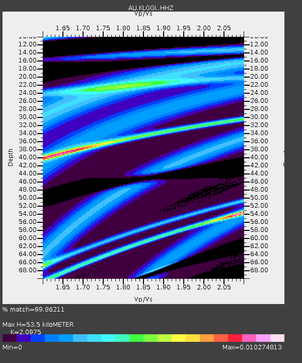
| Estimated Moho Depth: |
53.5 km |
| Estimated Crust Vp/Vs: |
2.10 |
| Assumed Crust Vp: |
6.459 km/s |
| Estimated Crust Vs: |
3.08 km/s |
| Estimated Crust Poisson's Ratio: |
0.35 |
|
| Radial Match: |
99.86211 % |
| Radial Bump: |
18 |
| Transverse Match: |
99.86211 % |
| Transverse Bump: |
18 |
| SOD ConfigId: |
28764291 |
| Insert Time: |
2022-11-08 00:15:34.569 +0000 |
| GWidth: |
2.5 |
| Max Bumps: |
400 |
| Tol: |
0.001 |
|

Signal To Noise
| Channel | StoN | STA | LTA |
| AU:KLGGI: :HHZ:20221025T00:25:09.23002Z | 2.6430905 | 6.5226664E-7 | 2.467818E-7 |
| AU:KLGGI: :HHN:20221025T00:25:09.23002Z | 2.6244824 | 7.9553547E-7 | 3.031209E-7 |
| $trig.getChannelId() | $trig.getValue() | $trig.getSTA() | $trig.getLTA() |
| Arrivals |
| Ps | 9.3 SECOND |
| PpPs | 25 SECOND |
| PsPs/PpSs | 34 SECOND |


