You are here: Home > Network List > G - GEOSCOPE Stations List
> Station MPG Montagne des Peres, French Guyana > Earthquake Result Viewer
MPG Montagne des Peres, French Guyana - Earthquake Result Viewer
| Earthquake location: |
South Sandwich Islands Region |
| Earthquake latitude/longitude: |
-58.7/-26.2 |
| Earthquake time(UTC): |
2022/10/25 (298) 00:13:02 GMT |
| Earthquake Depth: |
82 km |
| Earthquake Magnitude: |
6.3 Mww |
| Earthquake Catalog/Contributor: |
NEIC PDE/us |
|
| Network: |
G GEOSCOPE |
| Station: |
MPG Montagne des Peres, French Guyana |
| Lat/Lon: |
5.11 N/52.64 W |
| Elevation: |
147 m |
|
| Distance: |
67.1 deg |
| Az: |
331.155 deg |
| Baz: |
165.361 deg |
| Ray Param: |
0.057011444 |
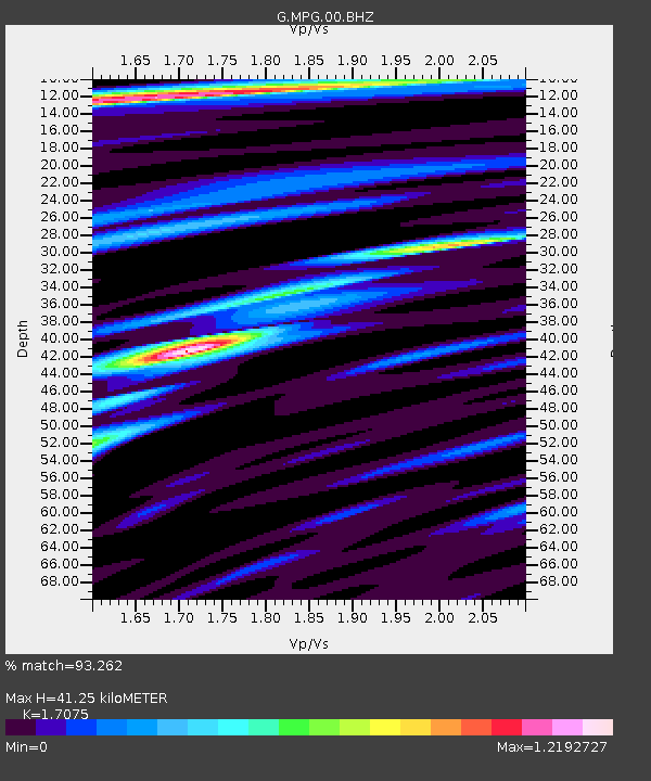
| Estimated Moho Depth: |
41.25 km |
| Estimated Crust Vp/Vs: |
1.71 |
| Assumed Crust Vp: |
6.472 km/s |
| Estimated Crust Vs: |
3.79 km/s |
| Estimated Crust Poisson's Ratio: |
0.24 |
|
| Radial Match: |
93.262 % |
| Radial Bump: |
400 |
| Transverse Match: |
80.91969 % |
| Transverse Bump: |
400 |
| SOD ConfigId: |
28764291 |
| Insert Time: |
2022-11-08 00:17:54.588 +0000 |
| GWidth: |
2.5 |
| Max Bumps: |
400 |
| Tol: |
0.001 |
|
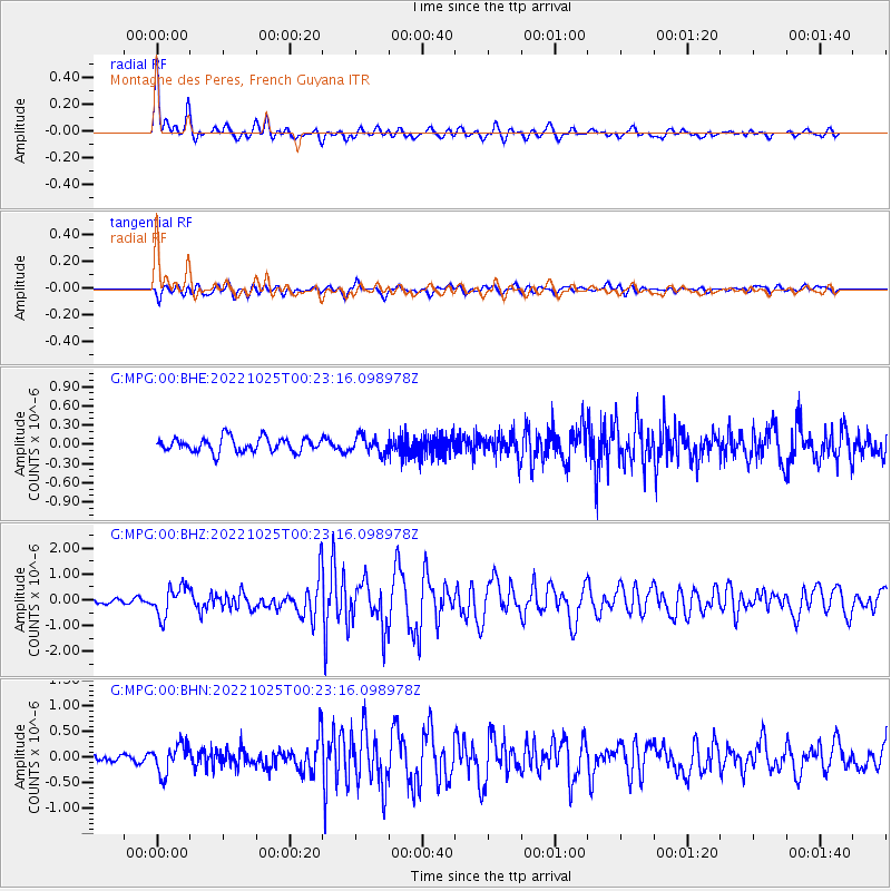
Signal To Noise
| Channel | StoN | STA | LTA |
| G:MPG:00:BHZ:20221025T00:23:16.098978Z | 6.4681487 | 5.7626505E-7 | 8.909273E-8 |
| G:MPG:00:BHN:20221025T00:23:16.098978Z | 4.0779 | 2.7729445E-7 | 6.799932E-8 |
| G:MPG:00:BHE:20221025T00:23:16.098978Z | 1.1861362 | 1.3276474E-7 | 1.11930426E-7 |
| Arrivals |
| Ps | 4.7 SECOND |
| PpPs | 17 SECOND |
| PsPs/PpSs | 21 SECOND |


