You are here: Home > Network List > TA - USArray Transportable Network (new EarthScope stations) Stations List
> Station H20A Greybull, WY, USA > Earthquake Result Viewer
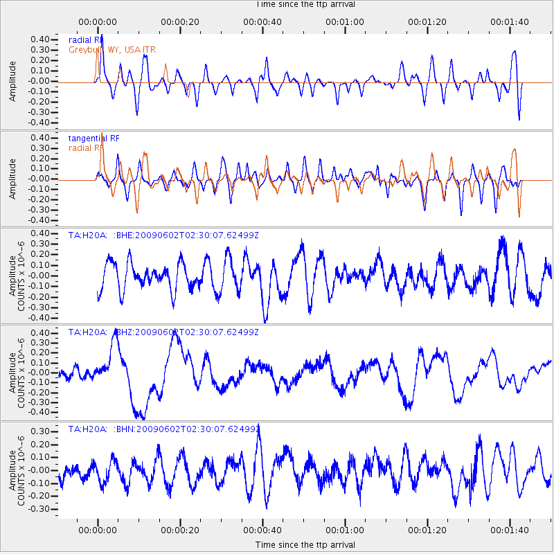
H20A Greybull, WY, USA - Earthquake Result Viewer
*The percent match for this event was below the threshold and hence no stack was calculated.
| Earthquake location: |
Vanuatu Islands |
| Earthquake latitude/longitude: |
-17.8/167.9 |
| Earthquake time(UTC): |
2009/06/02 (153) 02:17:03 GMT |
| Earthquake Depth: |
15 km |
| Earthquake Magnitude: |
5.7 MB, 6.2 MS, 6.3 MW, 6.3 MW |
| Earthquake Catalog/Contributor: |
WHDF/NEIC |
|
| Network: |
TA USArray Transportable Network (new EarthScope stations) |
| Station: |
H20A Greybull, WY, USA |
| Lat/Lon: |
44.49 N/108.00 W |
| Elevation: |
1236 m |
|
| Distance: |
98.1 deg |
| Az: |
45.98 deg |
| Baz: |
253.213 deg |
| Ray Param: |
$rayparam |
*The percent match for this event was below the threshold and hence was not used in the summary stack. |
|
| Radial Match: |
57.54416 % |
| Radial Bump: |
400 |
| Transverse Match: |
44.357334 % |
| Transverse Bump: |
400 |
| SOD ConfigId: |
296552 |
| Insert Time: |
2010-03-29 16:34:27.323 +0000 |
| GWidth: |
2.5 |
| Max Bumps: |
400 |
| Tol: |
0.001 |
|
Signal To Noise
| Channel | StoN | STA | LTA |
| TA:H20A: :BHZ:20090602T02:30:07.62499Z | 3.7533548 | 2.1647878E-7 | 5.7676075E-8 |
| TA:H20A: :BHN:20090602T02:30:07.62499Z | 0.7231531 | 8.906161E-8 | 1.2315733E-7 |
| TA:H20A: :BHE:20090602T02:30:07.62499Z | 1.3320075 | 1.6120528E-7 | 1.2102429E-7 |
| Arrivals |
| Ps | |
| PpPs | |
| PsPs/PpSs | |


