You are here: Home > Network List > AK - Alaska Regional Network Stations List
> Station L20K Alaska Regional Network > Earthquake Result Viewer
L20K Alaska Regional Network - Earthquake Result Viewer
| Earthquake location: |
Luzon, Philippines |
| Earthquake latitude/longitude: |
17.9/120.6 |
| Earthquake time(UTC): |
2022/10/25 (298) 14:59:04 GMT |
| Earthquake Depth: |
10 km |
| Earthquake Magnitude: |
6.8 Mi |
| Earthquake Catalog/Contributor: |
NEIC PDE/pt |
|
| Network: |
AK Alaska Regional Network |
| Station: |
L20K Alaska Regional Network |
| Lat/Lon: |
62.48 N/153.88 W |
| Elevation: |
673 m |
|
| Distance: |
72.2 deg |
| Az: |
29.095 deg |
| Baz: |
274.551 deg |
| Ray Param: |
0.053797286 |
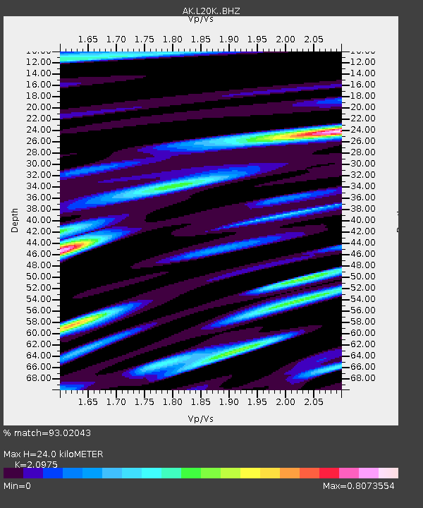
| Estimated Moho Depth: |
24.0 km |
| Estimated Crust Vp/Vs: |
2.10 |
| Assumed Crust Vp: |
6.566 km/s |
| Estimated Crust Vs: |
3.13 km/s |
| Estimated Crust Poisson's Ratio: |
0.35 |
|
| Radial Match: |
93.02043 % |
| Radial Bump: |
400 |
| Transverse Match: |
82.348526 % |
| Transverse Bump: |
400 |
| SOD ConfigId: |
28764291 |
| Insert Time: |
2022-11-08 15:05:55.159 +0000 |
| GWidth: |
2.5 |
| Max Bumps: |
400 |
| Tol: |
0.001 |
|

Signal To Noise
| Channel | StoN | STA | LTA |
| AK:L20K: :BHZ:20221025T15:09:57.97998Z | 13.291411 | 2.0090818E-6 | 1.511564E-7 |
| AK:L20K: :BHN:20221025T15:09:57.97998Z | 1.327872 | 2.4909778E-7 | 1.8759172E-7 |
| AK:L20K: :BHE:20221025T15:09:57.97998Z | 8.745921 | 9.1985464E-7 | 1.05175275E-7 |
| Arrivals |
| Ps | 4.1 SECOND |
| PpPs | 11 SECOND |
| PsPs/PpSs | 15 SECOND |


