You are here: Home > Network List > AK - Alaska Regional Network Stations List
> Station MDM Murphy Dome > Earthquake Result Viewer
MDM Murphy Dome - Earthquake Result Viewer
| Earthquake location: |
Luzon, Philippines |
| Earthquake latitude/longitude: |
17.9/120.6 |
| Earthquake time(UTC): |
2022/10/25 (298) 14:59:04 GMT |
| Earthquake Depth: |
10 km |
| Earthquake Magnitude: |
6.8 Mi |
| Earthquake Catalog/Contributor: |
NEIC PDE/pt |
|
| Network: |
AK Alaska Regional Network |
| Station: |
MDM Murphy Dome |
| Lat/Lon: |
64.96 N/148.23 W |
| Elevation: |
634 m |
|
| Distance: |
74.4 deg |
| Az: |
26.212 deg |
| Baz: |
278.786 deg |
| Ray Param: |
0.052337315 |
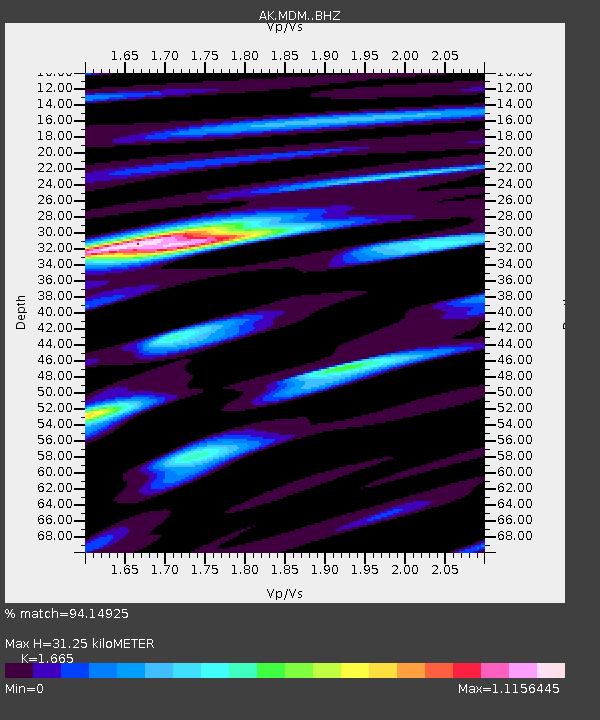
| Estimated Moho Depth: |
31.25 km |
| Estimated Crust Vp/Vs: |
1.66 |
| Assumed Crust Vp: |
6.566 km/s |
| Estimated Crust Vs: |
3.944 km/s |
| Estimated Crust Poisson's Ratio: |
0.22 |
|
| Radial Match: |
94.14925 % |
| Radial Bump: |
400 |
| Transverse Match: |
83.766045 % |
| Transverse Bump: |
400 |
| SOD ConfigId: |
28764291 |
| Insert Time: |
2022-11-08 15:06:17.850 +0000 |
| GWidth: |
2.5 |
| Max Bumps: |
400 |
| Tol: |
0.001 |
|

Signal To Noise
| Channel | StoN | STA | LTA |
| AK:MDM: :BHZ:20221025T15:10:10.968018Z | 36.643463 | 3.1211478E-6 | 8.517611E-8 |
| AK:MDM: :BHN:20221025T15:10:10.968018Z | 3.0562038 | 3.1815853E-7 | 1.04102526E-7 |
| AK:MDM: :BHE:20221025T15:10:10.968018Z | 7.5572267 | 1.0319627E-6 | 1.365531E-7 |
| Arrivals |
| Ps | 3.3 SECOND |
| PpPs | 12 SECOND |
| PsPs/PpSs | 16 SECOND |


