You are here: Home > Network List > AV - Alaska Volcano Observatory Stations List
> Station SPCL Chakachamna Lake, Mount Spurr, Alaska > Earthquake Result Viewer
SPCL Chakachamna Lake, Mount Spurr, Alaska - Earthquake Result Viewer
| Earthquake location: |
Luzon, Philippines |
| Earthquake latitude/longitude: |
17.9/120.6 |
| Earthquake time(UTC): |
2022/10/25 (298) 14:59:04 GMT |
| Earthquake Depth: |
10 km |
| Earthquake Magnitude: |
6.8 Mi |
| Earthquake Catalog/Contributor: |
NEIC PDE/pt |
|
| Network: |
AV Alaska Volcano Observatory |
| Station: |
SPCL Chakachamna Lake, Mount Spurr, Alaska |
| Lat/Lon: |
61.20 N/152.34 W |
| Elevation: |
1274 m |
|
| Distance: |
73.1 deg |
| Az: |
30.366 deg |
| Baz: |
276.285 deg |
| Ray Param: |
0.05324038 |
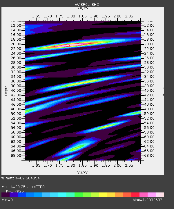
| Estimated Moho Depth: |
20.25 km |
| Estimated Crust Vp/Vs: |
1.79 |
| Assumed Crust Vp: |
6.566 km/s |
| Estimated Crust Vs: |
3.663 km/s |
| Estimated Crust Poisson's Ratio: |
0.27 |
|
| Radial Match: |
89.564354 % |
| Radial Bump: |
400 |
| Transverse Match: |
91.01566 % |
| Transverse Bump: |
400 |
| SOD ConfigId: |
28764291 |
| Insert Time: |
2022-11-08 15:11:10.842 +0000 |
| GWidth: |
2.5 |
| Max Bumps: |
400 |
| Tol: |
0.001 |
|

Signal To Noise
| Channel | StoN | STA | LTA |
| AV:SPCL: :BHZ:20221025T15:10:03.02002Z | 17.74575 | 2.1017574E-6 | 1.18437235E-7 |
| AV:SPCL: :BHN:20221025T15:10:03.02002Z | 2.7443235 | 4.1495184E-7 | 1.512037E-7 |
| AV:SPCL: :BHE:20221025T15:10:03.02002Z | 3.6328285 | 5.46865E-7 | 1.5053423E-7 |
| Arrivals |
| Ps | 2.5 SECOND |
| PpPs | 8.3 SECOND |
| PsPs/PpSs | 11 SECOND |


