You are here: Home > Network List > US - United States National Seismic Network Stations List
> Station DGMT Dagmar, Montana, USA > Earthquake Result Viewer
DGMT Dagmar, Montana, USA - Earthquake Result Viewer
*The percent match for this event was below the threshold and hence no stack was calculated.
| Earthquake location: |
Fiji Islands Region |
| Earthquake latitude/longitude: |
-17.9/-179.9 |
| Earthquake time(UTC): |
2018/09/21 (264) 03:40:40 GMT |
| Earthquake Depth: |
653 km |
| Earthquake Magnitude: |
5.9 Mww |
| Earthquake Catalog/Contributor: |
NEIC PDE/us |
|
| Network: |
US United States National Seismic Network |
| Station: |
DGMT Dagmar, Montana, USA |
| Lat/Lon: |
48.47 N/104.20 W |
| Elevation: |
0.0 m |
|
| Distance: |
94.1 deg |
| Az: |
40.295 deg |
| Baz: |
247.711 deg |
| Ray Param: |
$rayparam |
*The percent match for this event was below the threshold and hence was not used in the summary stack. |
|
| Radial Match: |
38.213467 % |
| Radial Bump: |
400 |
| Transverse Match: |
50.15444 % |
| Transverse Bump: |
400 |
| SOD ConfigId: |
2963291 |
| Insert Time: |
2018-10-05 03:54:32.843 +0000 |
| GWidth: |
2.5 |
| Max Bumps: |
400 |
| Tol: |
0.001 |
|
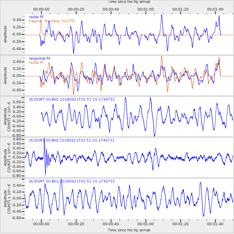
Signal To Noise
| Channel | StoN | STA | LTA |
| US:DGMT:00:BHZ:20180921T03:52:20.174973Z | 2.2274547 | 3.0811282E-7 | 1.3832506E-7 |
| US:DGMT:00:BH1:20180921T03:52:20.174973Z | 1.5815264 | 2.7058059E-7 | 1.7108825E-7 |
| US:DGMT:00:BH2:20180921T03:52:20.174973Z | 0.7938636 | 2.0176486E-7 | 2.5415557E-7 |
| Arrivals |
| Ps | |
| PpPs | |
| PsPs/PpSs | |


