You are here: Home > Network List > US - United States National Seismic Network Stations List
> Station HAWA Hanford, Washington, USA > Earthquake Result Viewer
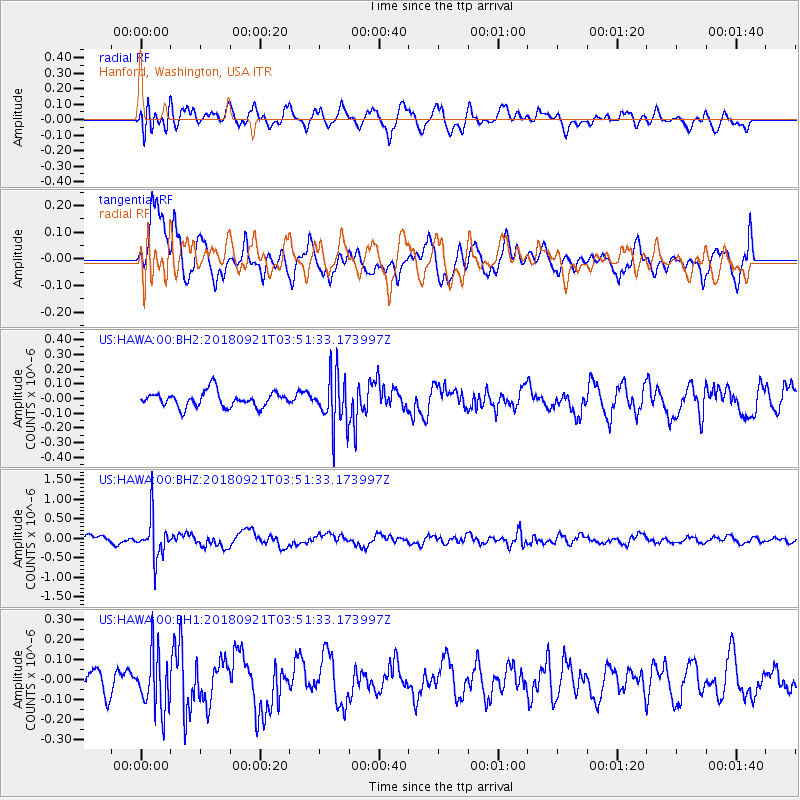
HAWA Hanford, Washington, USA - Earthquake Result Viewer
*The percent match for this event was below the threshold and hence no stack was calculated.
| Earthquake location: |
Fiji Islands Region |
| Earthquake latitude/longitude: |
-17.9/-179.9 |
| Earthquake time(UTC): |
2018/09/21 (264) 03:40:40 GMT |
| Earthquake Depth: |
653 km |
| Earthquake Magnitude: |
5.9 Mww |
| Earthquake Catalog/Contributor: |
NEIC PDE/us |
|
| Network: |
US United States National Seismic Network |
| Station: |
HAWA Hanford, Washington, USA |
| Lat/Lon: |
46.39 N/119.53 W |
| Elevation: |
364 m |
|
| Distance: |
84.0 deg |
| Az: |
37.246 deg |
| Baz: |
236.367 deg |
| Ray Param: |
$rayparam |
*The percent match for this event was below the threshold and hence was not used in the summary stack. |
|
| Radial Match: |
62.505543 % |
| Radial Bump: |
400 |
| Transverse Match: |
62.94852 % |
| Transverse Bump: |
400 |
| SOD ConfigId: |
2963291 |
| Insert Time: |
2018-10-05 03:54:38.884 +0000 |
| GWidth: |
2.5 |
| Max Bumps: |
400 |
| Tol: |
0.001 |
|
Signal To Noise
| Channel | StoN | STA | LTA |
| US:HAWA:00:BHZ:20180921T03:51:33.173997Z | 5.839932 | 5.121852E-7 | 8.770397E-8 |
| US:HAWA:00:BH1:20180921T03:51:33.173997Z | 1.8484418 | 1.4462913E-7 | 7.82438E-8 |
| US:HAWA:00:BH2:20180921T03:51:33.173997Z | 3.371629 | 1.7464319E-7 | 5.179787E-8 |
| Arrivals |
| Ps | |
| PpPs | |
| PsPs/PpSs | |


