You are here: Home > Network List > IU - Global Seismograph Network (GSN - IRIS/USGS) Stations List
> Station PMG Port Moresby, New Guinea > Earthquake Result Viewer
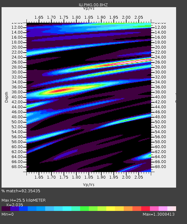
PMG Port Moresby, New Guinea - Earthquake Result Viewer
| Earthquake location: |
Luzon, Philippines |
| Earthquake latitude/longitude: |
17.9/120.6 |
| Earthquake time(UTC): |
2022/10/25 (298) 14:59:04 GMT |
| Earthquake Depth: |
10 km |
| Earthquake Magnitude: |
6.8 Mi |
| Earthquake Catalog/Contributor: |
NEIC PDE/pt |
|
| Network: |
IU Global Seismograph Network (GSN - IRIS/USGS) |
| Station: |
PMG Port Moresby, New Guinea |
| Lat/Lon: |
9.40 S/147.16 E |
| Elevation: |
90 m |
|
| Distance: |
37.7 deg |
| Az: |
133.888 deg |
| Baz: |
315.931 deg |
| Ray Param: |
0.07598675 |
| Estimated Moho Depth: |
25.5 km |
| Estimated Crust Vp/Vs: |
2.04 |
| Assumed Crust Vp: |
6.122 km/s |
| Estimated Crust Vs: |
3.008 km/s |
| Estimated Crust Poisson's Ratio: |
0.34 |
|
| Radial Match: |
92.35435 % |
| Radial Bump: |
400 |
| Transverse Match: |
74.90243 % |
| Transverse Bump: |
400 |
| SOD ConfigId: |
28764291 |
| Insert Time: |
2022-11-08 15:18:56.354 +0000 |
| GWidth: |
2.5 |
| Max Bumps: |
400 |
| Tol: |
0.001 |
|

Signal To Noise
| Channel | StoN | STA | LTA |
| IU:PMG:00:BHZ:20221025T15:05:48.819Z | 24.696766 | 2.6113369E-6 | 1.05735985E-7 |
| IU:PMG:00:BH1:20221025T15:05:48.819Z | 14.893008 | 1.341627E-6 | 9.008435E-8 |
| IU:PMG:00:BH2:20221025T15:05:48.819Z | 9.627895 | 1.033727E-6 | 1.0736792E-7 |
| Arrivals |
| Ps | 4.6 SECOND |
| PpPs | 12 SECOND |
| PsPs/PpSs | 17 SECOND |


