You are here: Home > Network List > TA - USArray Transportable Network (new EarthScope stations) Stations List
> Station E12A Beaver Dam Saddle, Pierce, ID, USA > Earthquake Result Viewer
E12A Beaver Dam Saddle, Pierce, ID, USA - Earthquake Result Viewer
| Earthquake location: |
Near East Coast Of Honshu, Japan |
| Earthquake latitude/longitude: |
35.5/140.9 |
| Earthquake time(UTC): |
2009/06/06 (157) 05:52:43 GMT |
| Earthquake Depth: |
34 km |
| Earthquake Magnitude: |
5.8 MB, 5.4 MS, 5.8 MW, 5.7 MW |
| Earthquake Catalog/Contributor: |
WHDF/NEIC |
|
| Network: |
TA USArray Transportable Network (new EarthScope stations) |
| Station: |
E12A Beaver Dam Saddle, Pierce, ID, USA |
| Lat/Lon: |
46.42 N/115.57 W |
| Elevation: |
1555 m |
|
| Distance: |
73.4 deg |
| Az: |
44.577 deg |
| Baz: |
304.113 deg |
| Ray Param: |
0.05296287 |
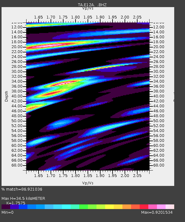
| Estimated Moho Depth: |
34.5 km |
| Estimated Crust Vp/Vs: |
1.76 |
| Assumed Crust Vp: |
6.622 km/s |
| Estimated Crust Vs: |
3.768 km/s |
| Estimated Crust Poisson's Ratio: |
0.26 |
|
| Radial Match: |
86.921036 % |
| Radial Bump: |
400 |
| Transverse Match: |
77.42253 % |
| Transverse Bump: |
400 |
| SOD ConfigId: |
296552 |
| Insert Time: |
2010-03-29 17:21:26.809 +0000 |
| GWidth: |
2.5 |
| Max Bumps: |
400 |
| Tol: |
0.001 |
|
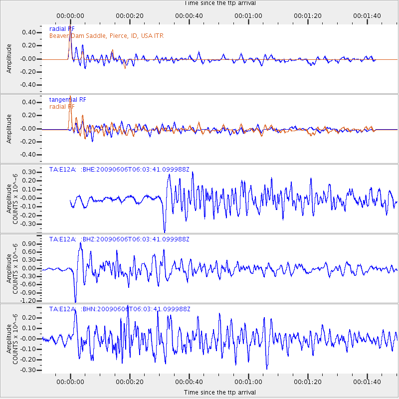
Signal To Noise
| Channel | StoN | STA | LTA |
| TA:E12A: :BHZ:20090606T06:03:41.099988Z | 20.215548 | 5.8153506E-7 | 2.8766726E-8 |
| TA:E12A: :BHN:20090606T06:03:41.099988Z | 5.1219916 | 1.1965805E-7 | 2.3361627E-8 |
| TA:E12A: :BHE:20090606T06:03:41.099988Z | 5.005872 | 1.7486676E-7 | 3.4932327E-8 |
| Arrivals |
| Ps | 4.1 SECOND |
| PpPs | 14 SECOND |
| PsPs/PpSs | 18 SECOND |


