You are here: Home > Network List > XA95 - Missouri to Massachusetts Transect Stations List
> Station MM08 Slippery Rock , Pennsylvania > Earthquake Result Viewer
MM08 Slippery Rock , Pennsylvania - Earthquake Result Viewer

| Earthquake location: |
Southern East Pacific Rise |
| Earthquake latitude/longitude: |
-35.4/-106.2 |
| Earthquake time(UTC): |
1995/10/12 (285) 23:41:45 GMT |
| Earthquake Depth: |
10 km |
| Earthquake Magnitude: |
5.5 MB, 5.3 MS, 5.9 UNKNOWN |
| Earthquake Catalog/Contributor: |
WHDF/NEIC |
|
| Network: |
XA Missouri to Massachusetts Transect |
| Station: |
MM08 Slippery Rock , Pennsylvania |
| Lat/Lon: |
41.11 N/80.07 W |
| Elevation: |
381 m |
|
| Distance: |
79.9 deg |
| Az: |
19.777 deg |
| Baz: |
201.455 deg |
| Ray Param: |
0.048678115 |
| Estimated Moho Depth: |
51.0 km |
| Estimated Crust Vp/Vs: |
1.68 |
| Assumed Crust Vp: |
6.483 km/s |
| Estimated Crust Vs: |
3.859 km/s |
| Estimated Crust Poisson's Ratio: |
0.23 |
|
| Radial Match: |
81.26481 % |
| Radial Bump: |
381 |
| Transverse Match: |
66.89391 % |
| Transverse Bump: |
400 |
| SOD ConfigId: |
29242 |
| Insert Time: |
2010-02-26 17:48:45.079 +0000 |
| GWidth: |
2.5 |
| Max Bumps: |
400 |
| Tol: |
0.001 |
|
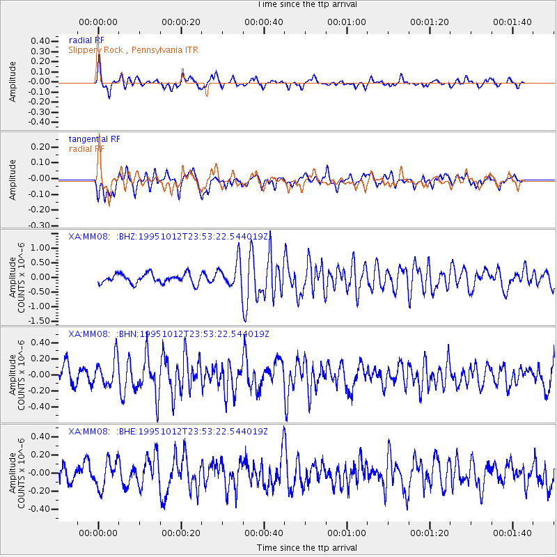
Signal To Noise
| Channel | StoN | STA | LTA |
| XA:MM08: :BHN:19951012T23:53:22.544019Z | 1.5902225 | 1.7659954E-7 | 1.1105335E-7 |
| XA:MM08: :BHE:19951012T23:53:22.544019Z | 1.2632139 | 1.5486083E-7 | 1.2259272E-7 |
| XA:MM08: :BHZ:19951012T23:53:22.544019Z | 2.8577993 | 4.6279047E-7 | 1.6193947E-7 |
| Arrivals |
| Ps | 5.5 SECOND |
| PpPs | 20 SECOND |
| PsPs/PpSs | 26 SECOND |


