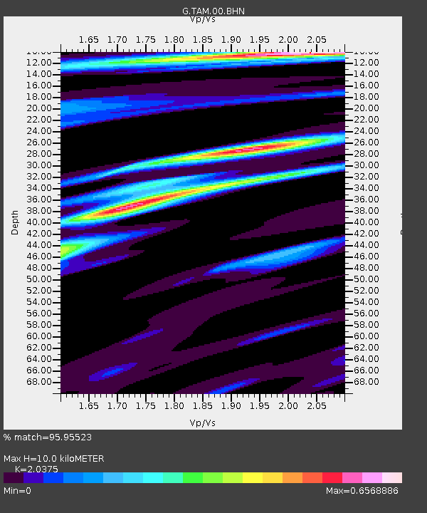
TAM Tamanrasset, Algeria - Earthquake Result Viewer
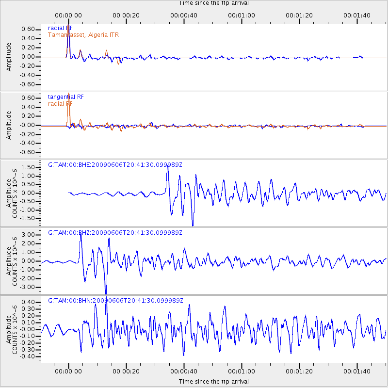
Earthquake location: Northern Mid-Atlantic Ridge
Earthquake latitude/longitude: 23.9/-46.1
Earthquake time(UTC): 2009/06/06 (157) 20:33:28 GMT
Earthquake Depth: 14 km
Earthquake Magnitude: 6.0 MB, 5.7 MS, 6.0 MW, 6.0 MW
Earthquake Catalog/Contributor: WHDF/NEIC
Network: G GEOSCOPE
Station: TAM Tamanrasset, Algeria
Lat/Lon: 22.79 N/5.53 E
Elevation: 1377 m
Distance: 47.2 deg
Az: 80.416 deg
Baz: 281.986 deg
Ray Param: 0.0701341
Estimated Moho Depth: 10.0 km
Estimated Crust Vp/Vs: 2.04
Assumed Crust Vp: 6.61 km/s
Estimated Crust Vs: 3.244 km/s
Estimated Crust Poisson's Ratio: 0.34
Radial Match: 95.95523 %
Radial Bump: 210
Transverse Match: 85.944336 %
Transverse Bump: 400
SOD ConfigId: 296552
Insert Time: 2010-03-29 17:27:09.892 +0000
GWidth: 2.5
Max Bumps: 400
Tol: 0.001

Signal To Noise

ChannelStoNSTALTA
G:TAM:00:BHZ:20090606T20:41:30.099989Z13.8763951.0041674E-67.236515E-8
G:TAM:00:BHN:20090606T20:41:30.099989Z2.15978349.240227E-84.2783117E-8
G:TAM:00:BHE:20090606T20:41:30.099989Z9.3771015.448667E-75.8106092E-8
Arrivals
Ps1.7 SECOND
PpPs4.3 SECOND
PsPs/PpSs6.0 SECOND