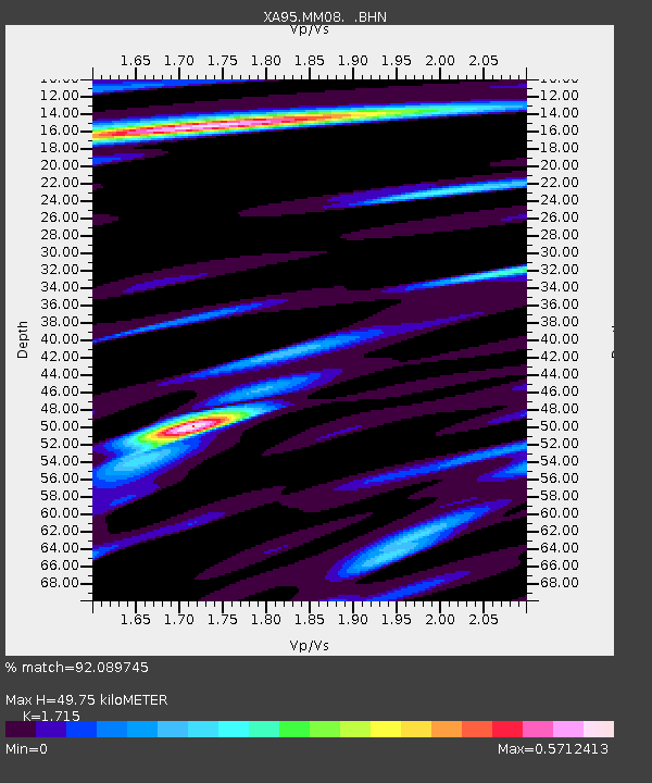
MM08 Slippery Rock , Pennsylvania - Earthquake Result Viewer

Earthquake location: Peru-Ecuador Border Region
Earthquake latitude/longitude: -2.8/-77.9
Earthquake time(UTC): 1995/10/03 (276) 12:45:00 GMT
Earthquake Depth: 33 km
Earthquake Magnitude: 6.0 MB, 6.1 MS, 5.9 UNKNOWN, 6.4 MW
Earthquake Catalog/Contributor: WHDF/NEIC
Network: XA Missouri to Massachusetts Transect
Station: MM08 Slippery Rock , Pennsylvania
Lat/Lon: 41.11 N/80.07 W
Elevation: 381 m
Distance: 43.8 deg
Az: 357.628 deg
Baz: 176.864 deg
Ray Param: 0.07227397
Estimated Moho Depth: 49.75 km
Estimated Crust Vp/Vs: 1.72
Assumed Crust Vp: 6.483 km/s
Estimated Crust Vs: 3.78 km/s
Estimated Crust Poisson's Ratio: 0.24
Radial Match: 92.089745 %
Radial Bump: 317
Transverse Match: 54.311207 %
Transverse Bump: 400
SOD ConfigId: 6273
Insert Time: 2010-02-26 17:48:47.655 +0000
GWidth: 2.5
Max Bumps: 400
Tol: 0.001

Signal To Noise

ChannelStoNSTALTA
XA:MM08: :BHN:19951003T12:52:31.946008Z5.5848348.485744E-71.5194264E-7
XA:MM08: :BHE:19951003T12:52:31.946008Z0.62144651.11323544E-71.7913617E-7
XA:MM08: :BHZ:19951003T12:52:31.946008Z7.45472151.6261455E-62.1813632E-7
Arrivals
Ps5.9 SECOND
PpPs19 SECOND
PsPs/PpSs25 SECOND