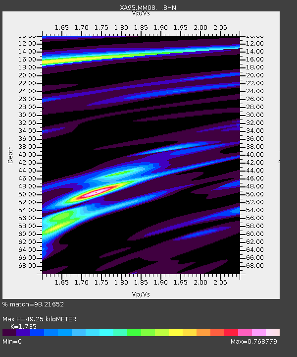
MM08 Slippery Rock , Pennsylvania - Earthquake Result Viewer
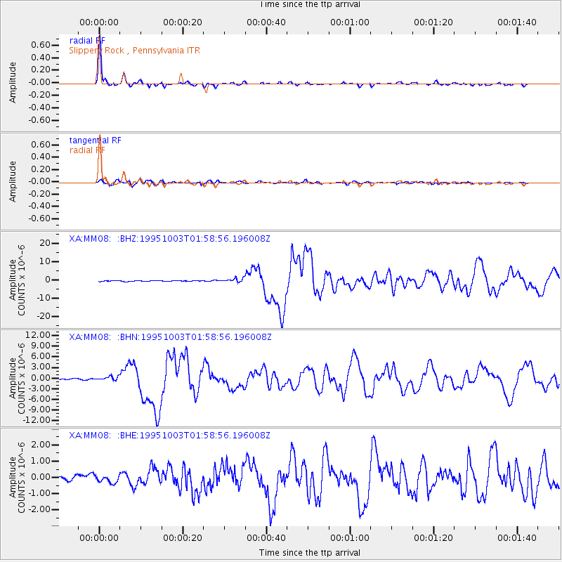
Earthquake location: Peru-Ecuador Border Region
Earthquake latitude/longitude: -2.8/-77.9
Earthquake time(UTC): 1995/10/03 (276) 01:51:24 GMT
Earthquake Depth: 27 km
Earthquake Magnitude: 6.5 MB, 7.0 MS, 6.9 UNKNOWN, 7.0 MW
Earthquake Catalog/Contributor: WHDF/NEIC
Network: XA Missouri to Massachusetts Transect
Station: MM08 Slippery Rock , Pennsylvania
Lat/Lon: 41.11 N/80.07 W
Elevation: 381 m
Distance: 43.7 deg
Az: 357.612 deg
Baz: 176.843 deg
Ray Param: 0.072319865
Estimated Moho Depth: 49.25 km
Estimated Crust Vp/Vs: 1.74
Assumed Crust Vp: 6.483 km/s
Estimated Crust Vs: 3.736 km/s
Estimated Crust Poisson's Ratio: 0.25
Radial Match: 98.21652 %
Radial Bump: 263
Transverse Match: 80.02134 %
Transverse Bump: 400
SOD ConfigId: 6273
Insert Time: 2010-02-26 17:48:48.776 +0000
GWidth: 2.5
Max Bumps: 400
Tol: 0.001

Signal To Noise

ChannelStoNSTALTA
XA:MM08: :BHN:19951003T01:58:56.196008Z3.59726725.811797E-71.6156145E-7
XA:MM08: :BHE:19951003T01:58:56.196008Z1.54431412.1753506E-71.4086193E-7
XA:MM08: :BHZ:19951003T01:58:56.196008Z5.3657611.0604341E-61.9762977E-7
Arrivals
Ps6.0 SECOND
PpPs19 SECOND
PsPs/PpSs25 SECOND