You are here: Home > Network List > G - GEOSCOPE Stations List
> Station MPG Montagne des Peres, French Guyana > Earthquake Result Viewer
MPG Montagne des Peres, French Guyana - Earthquake Result Viewer

| Earthquake location: |
Near Coast Of Peru |
| Earthquake latitude/longitude: |
-14.5/-76.2 |
| Earthquake time(UTC): |
2022/10/28 (301) 20:22:06 GMT |
| Earthquake Depth: |
16 km |
| Earthquake Magnitude: |
5.9 mww |
| Earthquake Catalog/Contributor: |
NEIC PDE/us |
|
| Network: |
G GEOSCOPE |
| Station: |
MPG Montagne des Peres, French Guyana |
| Lat/Lon: |
5.11 N/52.64 W |
| Elevation: |
147 m |
|
| Distance: |
30.4 deg |
| Az: |
51.737 deg |
| Baz: |
229.764 deg |
| Ray Param: |
0.07942435 |
| Estimated Moho Depth: |
39.0 km |
| Estimated Crust Vp/Vs: |
1.74 |
| Assumed Crust Vp: |
6.472 km/s |
| Estimated Crust Vs: |
3.73 km/s |
| Estimated Crust Poisson's Ratio: |
0.25 |
|
| Radial Match: |
90.115654 % |
| Radial Bump: |
311 |
| Transverse Match: |
66.13707 % |
| Transverse Bump: |
400 |
| SOD ConfigId: |
29669891 |
| Insert Time: |
2022-11-11 21:34:19.272 +0000 |
| GWidth: |
2.5 |
| Max Bumps: |
400 |
| Tol: |
0.001 |
|
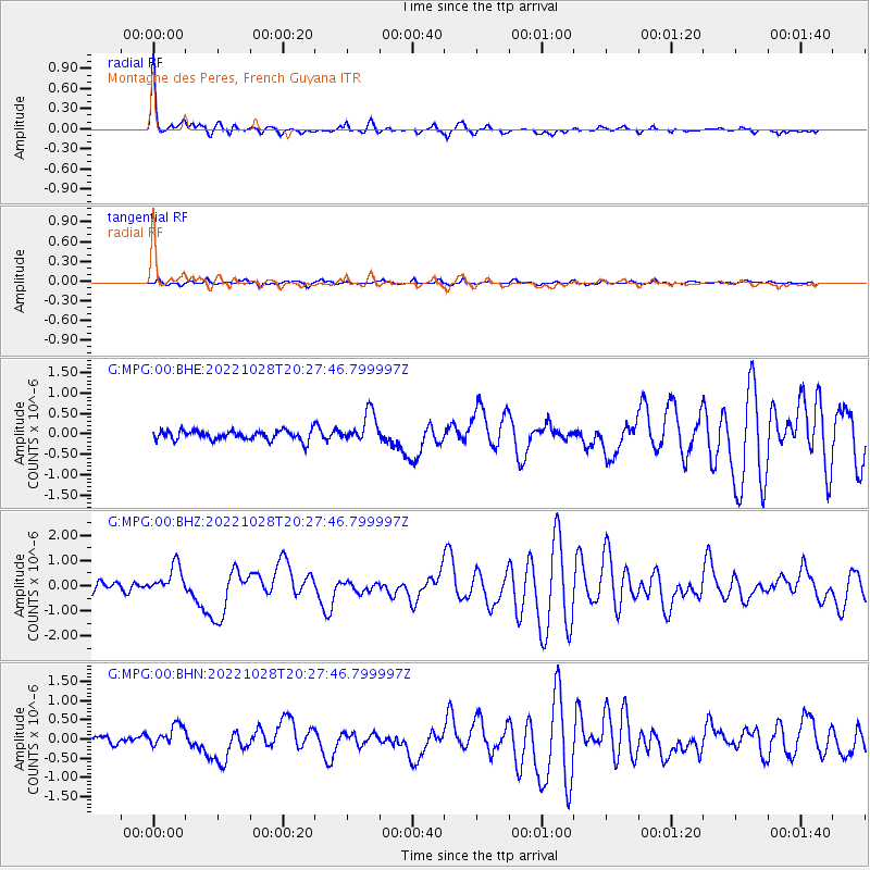
Signal To Noise
| Channel | StoN | STA | LTA |
| G:MPG:00:BHZ:20221028T20:27:46.799997Z | 3.727981 | 5.5696273E-7 | 1.4940062E-7 |
| G:MPG:00:BHN:20221028T20:27:46.799997Z | 2.7138298 | 2.76077E-7 | 1.0172967E-7 |
| G:MPG:00:BHE:20221028T20:27:46.799997Z | 3.137669 | 3.7252423E-7 | 1.18726426E-7 |
| Arrivals |
| Ps | 4.8 SECOND |
| PpPs | 15 SECOND |
| PsPs/PpSs | 20 SECOND |


