You are here: Home > Network List > IU - Global Seismograph Network (GSN - IRIS/USGS) Stations List
> Station SLBS Sierra la Laguna Baja California Sur, Mexico > Earthquake Result Viewer
SLBS Sierra la Laguna Baja California Sur, Mexico - Earthquake Result Viewer
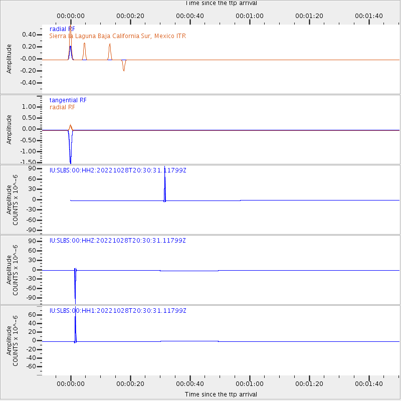
| Earthquake location: |
Near Coast Of Peru |
| Earthquake latitude/longitude: |
-14.5/-76.2 |
| Earthquake time(UTC): |
2022/10/28 (301) 20:22:06 GMT |
| Earthquake Depth: |
16 km |
| Earthquake Magnitude: |
5.9 mww |
| Earthquake Catalog/Contributor: |
NEIC PDE/us |
|
| Network: |
IU Global Seismograph Network (GSN - IRIS/USGS) |
| Station: |
SLBS Sierra la Laguna Baja California Sur, Mexico |
| Lat/Lon: |
23.69 N/109.94 W |
| Elevation: |
825 m |
|
| Distance: |
50.3 deg |
| Az: |
318.522 deg |
| Baz: |
135.599 deg |
| Ray Param: |
0.06810877 |
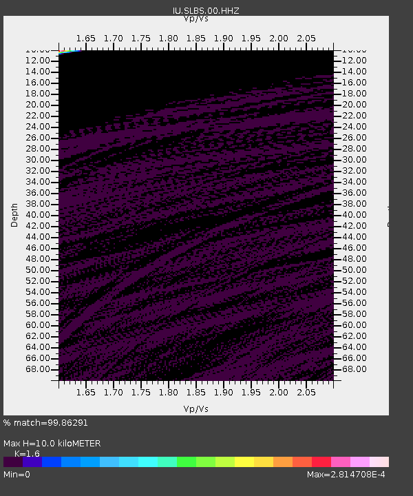
| Estimated Moho Depth: |
10.0 km |
| Estimated Crust Vp/Vs: |
1.60 |
| Assumed Crust Vp: |
6.183 km/s |
| Estimated Crust Vs: |
3.864 km/s |
| Estimated Crust Poisson's Ratio: |
0.18 |
|
| Radial Match: |
99.86291 % |
| Radial Bump: |
33 |
| Transverse Match: |
99.993385 % |
| Transverse Bump: |
4 |
| SOD ConfigId: |
29669891 |
| Insert Time: |
2022-11-11 21:36:32.114 +0000 |
| GWidth: |
2.5 |
| Max Bumps: |
400 |
| Tol: |
0.001 |
|
Signal To Noise
| Channel | StoN | STA | LTA |
| IU:SLBS:00:HHZ:20221028T20:30:31.11799Z | 98.69053 | 1.8636727E-5 | 1.8884008E-7 |
| IU:SLBS:00:HH1:20221028T20:30:31.11799Z | 100.79457 | 1.2358586E-5 | 1.2261162E-7 |
| IU:SLBS:00:HH2:20221028T20:30:31.11799Z | 96.516846 | 1.6321097E-5 | 1.6910101E-7 |
| Arrivals |
| Ps | 1.0 SECOND |
| PpPs | 4.0 SECOND |
| PsPs/PpSs | 5.0 SECOND |


