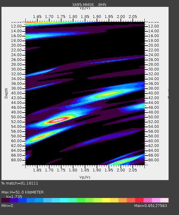
MM08 Slippery Rock , Pennsylvania - Earthquake Result Viewer
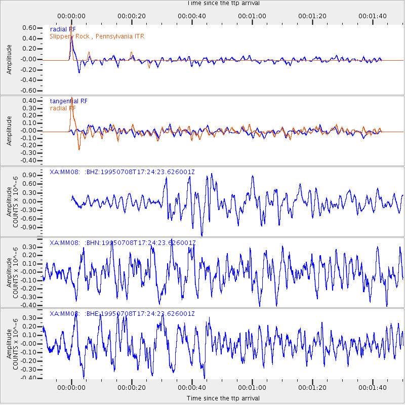
Earthquake location: Unimak Island Region, Alaska
Earthquake latitude/longitude: 53.6/-163.5
Earthquake time(UTC): 1995/07/08 (189) 17:15:28 GMT
Earthquake Depth: 33 km
Earthquake Magnitude: 5.8 MB, 5.7 MS, 5.5 UNKNOWN, 6.0 MW
Earthquake Catalog/Contributor: WHDF/NEIC
Network: XA Missouri to Massachusetts Transect
Station: MM08 Slippery Rock , Pennsylvania
Lat/Lon: 41.11 N/80.07 W
Elevation: 381 m
Distance: 54.7 deg
Az: 66.85 deg
Baz: 313.577 deg
Ray Param: 0.065199696
Estimated Moho Depth: 51.0 km
Estimated Crust Vp/Vs: 1.74
Assumed Crust Vp: 6.483 km/s
Estimated Crust Vs: 3.736 km/s
Estimated Crust Poisson's Ratio: 0.25
Radial Match: 81.18111 %
Radial Bump: 400
Transverse Match: 66.32541 %
Transverse Bump: 400
SOD ConfigId: 6273
Insert Time: 2010-02-26 17:48:55.846 +0000
GWidth: 2.5
Max Bumps: 400
Tol: 0.001

Signal To Noise

ChannelStoNSTALTA
XA:MM08: :BHN:19950708T17:24:23.626001Z1.88527421.6213954E-78.600317E-8
XA:MM08: :BHE:19950708T17:24:23.626001Z2.42598062.0769646E-78.561341E-8
XA:MM08: :BHZ:19950708T17:24:23.626001Z2.80403453.954367E-71.4102419E-7
Arrivals
Ps6.1 SECOND
PpPs20 SECOND
PsPs/PpSs26 SECOND